Southwest 2025-7. Colorado: Durango, Silverton, Ouray, Million Dollar Highway. Utah: Return to Green River
May 11–16, 2025

The Million Dollar Highway is another "dangerous" road that we love to drive. We'd planned to drive it earlier in the trip, and it IS open year-round, but we don't relish driving in snow. Now, after a few days with family and friends in Boulder/Denver, repairs to the van's electric system at VanWorks in Fort Collins, and a couple days in the gorgeous San Luis Valley, it was time to go south to Durango to head north to Ouray. We did say we have an elastic itinerary?

We encountered interesting houses and animals going through Center CO.


Being federal, the campground was half price for us old folks. We liked it so much, we reserved a second night in the morning, then headed north to Silverton.

.jpeg)


.jpeg)


We'd debated taking the Durango & Silverton Narrow Gauge Railroad, and somewhat regretted our decision not to.

Utes and Anasazi inhabited this area of the San Juan Range of the Rockies before it was "discovered." Gold mining lasted for about 30 years in the late 19th and early 20th centuries.
.jpeg)
.jpeg)
.jpeg)
.jpeg)
.jpeg)
.jpeg)

.jpeg)
.jpeg)

After another night at Lake Haviland, we retraced our steps to Silverton, bypassing the town, and continued north on the Million Dollar Highway.


Telluride
Doug had always wanted to see Telluride. Marilyn was sure she'd seen a direct route from Ouray on the map. Indeed, there is a 4WD road option to the highway.


Ridgeway is the home of the Rio Grande Southern Railroad, which ran from Ridgeway over the Dallas Divide to Durango, servicing mining communities en route. When the Great Depression made steam locomotives unaffordable, RGSR's chief mechanic invented railcars built from recycled Buicks and Pierce Arrows. The "Motors," which ran on gas, were nicknamed "Galloping Geese," for their looks and honking noises.

The Nuchu (Ute) inhabited what they called the Shining Mountain region for 10,000 years before miners and the attendant businesses arrived in the 1870s. Telluride became a ski resort in 1972.

We decided not to camp in Telluride as planned and instead headed northeast to Green River UT.


Our route took us through Paradox Valley at about 5,000 feet then up a steep climb to Paradox Valley Viewpoint. What is paradoxical about the valley? Rather than running north-south down the valley, the Dolores River runs west-east.


Moab was overflowing with springbreakers, and we figured a campsite would be hard to come by anyway, so we continued on to Green River. We'd stayed there at the KOA before and visited the Powell River History Museum 4-1/2 weeks before. Our 2,950-mile route since then had taken us southeast to Las Cruces NM, north to Boulder CO, southwest to Durango CO, northeast back to Green River, UT. The campground we chose instead of staying at the KOA again was not ideal, but we'd be off on the road again in the morning.
Where to next? Southwest to Capitol Reef National Park, Boulder UT and the Burr Trail, Bryce Canyon National Park.

Lake Haviland, north of Durango CO.
The Million Dollar Highway is another "dangerous" road that we love to drive. We'd planned to drive it earlier in the trip, and it IS open year-round, but we don't relish driving in snow. Now, after a few days with family and friends in Boulder/Denver, repairs to the van's electric system at VanWorks in Fort Collins, and a couple days in the gorgeous San Luis Valley, it was time to go south to Durango to head north to Ouray. We did say we have an elastic itinerary?

Quonset hut house & barn, with stunning views.
We encountered interesting houses and animals going through Center CO.
Silo house.
What's for dinner?

Crossing the Rio Grande into Del Norte.

The door was locked at Chavolo's Mexican Restaurant in Del Norte, but the owner called to us as we returned to the van, saying come back, they were abierto! Breakfast was delicious.

Poster at Chavalo's: Colorado is known for its "Fourteeners"—
mountain peaks 14,000 feet & above.
For some, climbing as many Fourteeners as possible is a goal.
Marilyn decided the van kitchen needed an upgrade.

Rio Grande in South Fork. Doug camped at 10,000 feet above South Fork in 2024 en route across the country for our Eastern Canada adventure.
Rio Grande National Forest.
Avalanche tunnel.


Wolf Creek Pass at 10,882 feet crosses the Continental Divide. The Continental Divide Trail follows the divide through the US from Mexico to Canada.

Marilyn would have to stop & study this sign, so took a picture, not that it helps the confusion much.... Doug with his jet pilot experience takes in all his surroundings in passing.

Chimney Rock National Monument, a Chacoan site with some excavated ruins in San Juan Range of Rocky Mountains.
Wildlife Bridge, San Juan NF.

We drove through Durango & north to the lovely and quiet Haviland Lake Campground, at 8,700 feet.

Haviland Lake.

Near 10,640' Coal Bank Pass, San Juan National Forest, en route to Silverton.
.jpeg)

Narrow road with no guardrails, so snowplows can simply push the snow over the edge, & lots of hairpin curves.


Almost to 10,910' Molas Pass.
.jpeg)
Molas Lake, still largely frozen.
Driving to Silverton.

Former mining town Silverton is at 9,300+ feet.

Iron oxide deposits on slopes.


The streets of Silverton.

Utes and Anasazi inhabited this area of the San Juan Range of the Rockies before it was "discovered." Gold mining lasted for about 30 years in the late 19th and early 20th centuries.
.jpeg)
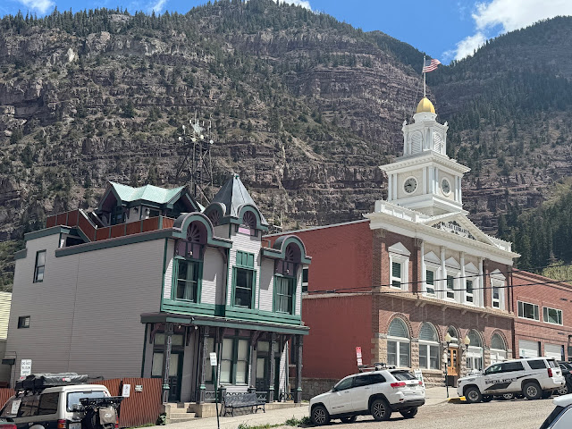
Silverton's main street. Town Hall on right. Our van on left.
.jpeg)
House that gives neighbors a view. Part of the fun of just taking our time is exploring neighborhoods.
.jpeg)
.jpeg)
Entire roof is planted.
.jpeg)
.jpeg)
New & old: geodesic dome home & San Juan County Historical Society Museum, 1907, formerly county courthouse.

1883 Queen Ann style Victorian house, 1 of 3 designed & built by Emma Harris, who was born in Russia, moved with her family to Illinois then to Silver Camp CO, where she married a Welsh miner.
.jpeg)
.jpeg)
Most of Silverton's houses were built 1880-1910, largely in the Queen Anne Style.

Silverton's dirt streets reminded us of Dawson City, Yukon.

11,018' Red Mountain Pass on the Million Dollar Highway between Silverton & Ouray.

Million Dollar Highway is 23 to 45 feet wide & mostly has no guardrails, to allow plows to push snow over the edge rather than making huge berms on the narrow shoulders. Average annual snowfall is 25 feet.
Narrow road, no guardrail, slim shoulders—& construction.

Bear Creek Falls drops 200' into Uncompahgre River Gorge.

Viewing platform.

Not as far down as New Mexico's Rio Grande Gorge, but...

San Juan Mountains: Bear Creek below, 12,800' Mt Abrams to south.

Ripples were formed by water over the ages.

Bear Creek National Recreation Trailhead crossing over Million Dollar Hwy.

Ouray, the "Switzerland of America."

Mt Abrams: view to south from Ouray Hot Springs.
Uncompahgre River behind our campsite.

Lovely spring morning at 4J+1+1 Campground. Note, we are hooked to electricity for our portable heater—it was cold in the mornings.

Marilyn took advantage of the hot springs complex to swim in the 25-meter lap pool, heated to about 80°. Hot pools are about 106°.

We awoke our 2nd morning to the return of winter, with a trace of snow, but the heater kept us warm. Marilyn opted not to swim.

Ouray County Courthouse, 1888.
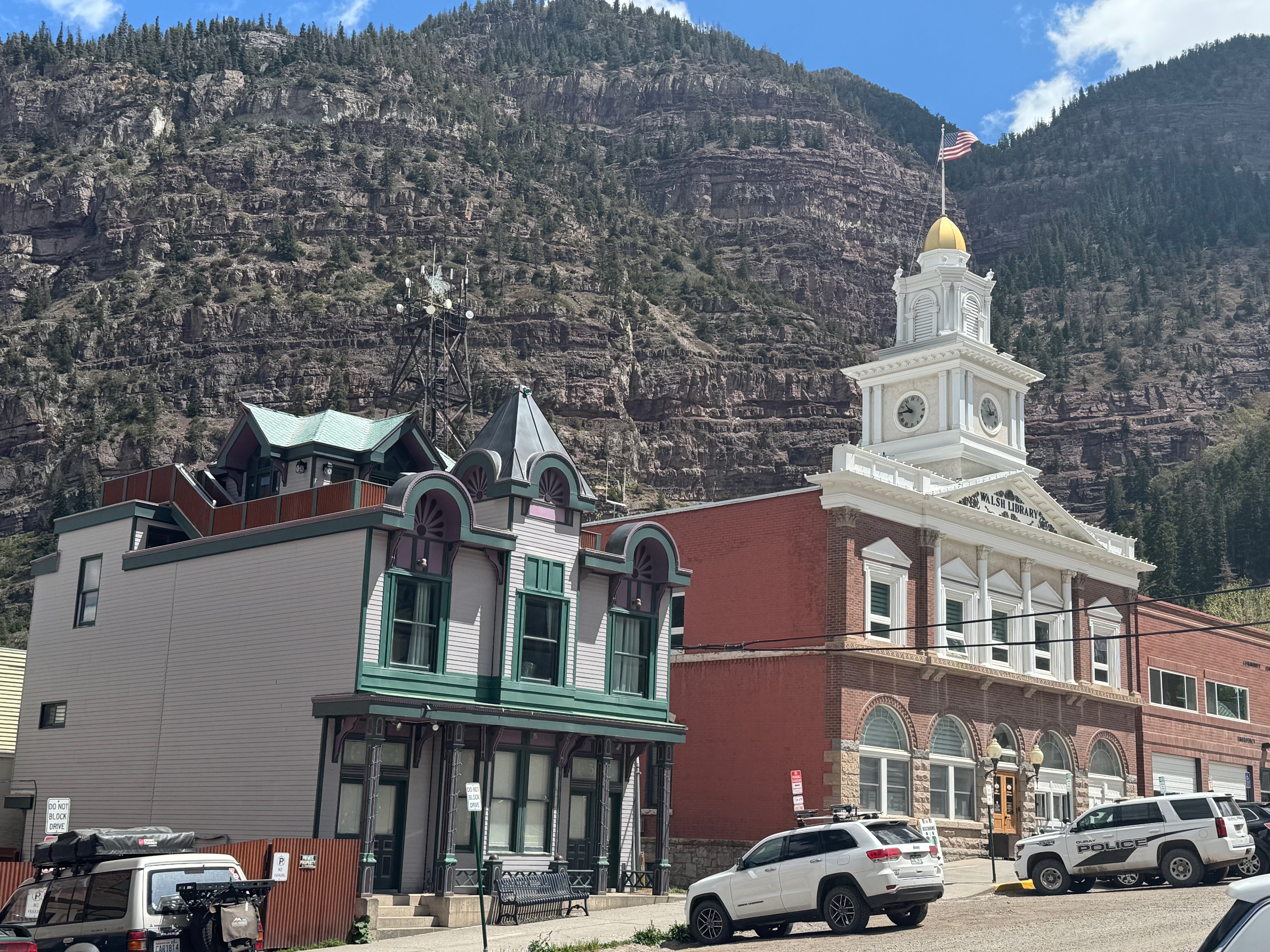
Ouray City Hall & Walsh Library (middle), originally built 1900, burned down 1950, restored 1988. Ouray Fire Station (far right).

BPOE, 1904.

Dirt streets & snow.

Our final day dawned a bit more spring-like, enticing Marilyn back to the lap pool.
Telluride
Doug had always wanted to see Telluride. Marilyn was sure she'd seen a direct route from Ouray on the map. Indeed, there is a 4WD road option to the highway.

Green route, the highway, reaches 9,000' with views of snow-capped peaks. Purple is 4WD up to 13,000' with many switchbacks—not enticing even if we did have 4WD.
4WD road switchbacks from Telluride.

View from Dallas Divide. Not a great pic, but you get the idea.

Goose #4 railcar of Rio Grande Southern Railroad, Ridgeway.
Ridgeway is the home of the Rio Grande Southern Railroad, which ran from Ridgeway over the Dallas Divide to Durango, servicing mining communities en route. When the Great Depression made steam locomotives unaffordable, RGSR's chief mechanic invented railcars built from recycled Buicks and Pierce Arrows. The "Motors," which ran on gas, were nicknamed "Galloping Geese," for their looks and honking noises.

Driving into Telluride. Convening of the elks: the leader speaks from the front.
The Nuchu (Ute) inhabited what they called the Shining Mountain region for 10,000 years before miners and the attendant businesses arrived in the 1870s. Telluride became a ski resort in 1972.

Idarado Mine uranium-radium mine closed in 1978. Reclamation & remediation were done from 1992 to 1997.
Following along the San Miguel River.


Local animal life.
Our route took us through Paradox Valley at about 5,000 feet then up a steep climb to Paradox Valley Viewpoint. What is paradoxical about the valley? Rather than running north-south down the valley, the Dolores River runs west-east.

Paradox Valley CO. The Dolores River runs across rather than parallel to the valley & eventually into the Colorado.
Back in Utah.

More of Utah's amazing formations.

Moab was overflowing with springbreakers, and we figured a campsite would be hard to come by anyway, so we continued on to Green River. We'd stayed there at the KOA before and visited the Powell River History Museum 4-1/2 weeks before. Our 2,950-mile route since then had taken us southeast to Las Cruces NM, north to Boulder CO, southwest to Durango CO, northeast back to Green River, UT. The campground we chose instead of staying at the KOA again was not ideal, but we'd be off on the road again in the morning.
Southwest 2025-7: 5 days/602 mi.

Our entire Southwest 2025 trip: 6.5 weeks/6,274 mi.

Southwest 2025: 6-1/2 weeks. 6,273.5 miles. (1) Visalia CA-Green River UT. (2) Green River-Ship Rock NM. (3) Ship Rock-Aldo Leopold Wilderness. (4) Leopold-Carrizozo. (5) Carrizozo-Taos. (6) Taos-Grand Villa CO. (7) Grand Villa-Green River UT. (8) Green River-Kanab. (9) Kanab-Kanab. (10) Kanab-Bridgeport CA. (11) Bridgeport-Visalia.
Where to next? Southwest to Capitol Reef National Park, Boulder UT and the Burr Trail, Bryce Canyon National Park.
I enjoyed Colorado and its historic towns through your eyes. 👀 🚐 K. Parker
ReplyDeleteThank you, Kathleen. Hopefully you'll be able to visit in person some day.
DeleteFun stuff. Thanks for the stories.
ReplyDeleteAlways love an audience for story telling:-)
Delete