Southwest 2025-5: Santa Fe, Los Alamos, Rio Grande River Gorge, Taos, Angel Fire
April 28 – May 3, 2025
Santa Fe

We made a reservation at Hotel Chimayo in Santa Fe about a week before we decided we'd get there. We could cancel a day before arrival should we encounter a road that beckoned us to explore. Doug really wanted to be close to the Plaza. Hotel Chimayo fit the bill perfectly being just steps away.


New Mexico is called the "Land of Enchantment," and Santa Fe embodies that in every sense, from its adobe and wood architecture, to its colors and art, to its atmosphere of magic, to its narrow streets and portales (colonnades), all reflections of its Puebloan, Spanish, and Mexican heritage.


A Mexican trader led the first trading caravan from Abiquiu NM to Los Angeles CA in 1829, on what became known as the Spanish Trail. As commerce increased, other traders created other trails, including the Santa Fe. It was over the Santa Fe Trail that the stained glass windows from France for the Loretto Chapel were carried. 
Doug did a walking tour that was very informative, including the story of Loretto Chapel's staircase. The chapel for the Sisters of Loretto was under construction in the late 19th century when the bishop in charge died. There was no staircase to the loft. With no money at their disposal, the sisters prayed. A stranger showed up and built a staircase of wood not from the area. It was 20-feet tall, had no nails or center support, and included two 360-degree spirals. The stranger disappeared without being paid.


.jpeg)
.jpeg)


If only we could import the wonderful water features we saw on our trip to our yard....
 Palace Ave around the corner from our hotel.


Los Alamos


The early-20th century houses of 20th Street, formerly faculty housing of the Los Alamos Ranch School, whose grounds the government purchased, were home to head scientific and military personnel of the Manhattan Project. Housing quickly built for the thousands who moved to Los Alamos to work on the Manhattan Project had only showers, whereas the older 20th Street houses had bathtubs, as well. Thus 20th Street was dubbed “Bathtub Row.” (The "Tub," i.e., Bathtub Row Brewing Coop, is in downtown Los Alamos.)
 Oppenheimer house, Bathtub Row.
Doug performed a fun multiple-point turn (remember, he was driving our 17.5-foot van) on narrow Bath Tub Row and got us back on the main road. We found Bradbury Science Museum, named for Norman Bradbury, Manhattan Project scientist (not writer Ray Bradbury author of Dandelion Wine, one of Marilyn's favorite books).


Despite knowing its terrifying height from a previous visit, we drove out to the Rio Grande Gorge Bridge.


We turned back toward Taos then north on the 84-mile Enchanted Circle National Forest Scenic Byway


 Meanwhile, we hit 3,000 miles for the 2-1/2 weeks since leaving home—only 3,274 to go, not that we knew that then. We'd spend an additional nearly 4 weeks visiting family & friends & meandering through amazing country.


Miners sought gold near Questa in the late 19th century. By 1900, the search switched to molybdenum. A large mining operation owned by Molycorp, then Union Oil, then Chevron, became a Superfund Cleanup Site in 2009 and closed in 2014. Both surface and ground water had been contaminated. Chevron has built a solar farm and in 2025 reached an agreement over water rights with local businesses and communities.


Back in Taos, we walked along the arcades of the Plaza, built by the Spanish for defense 400 years ago. Marilyn strolled down Ledoux Street and back, taking in the doors, adobes, art, and blues. Originally designed like a fortress with gates at each end, today the area is home to numerous museums.

Why are the doors and trim of so many New Mexico buildings painted blue? Theories vary.


Turquoise plays a significant role in the New Mexico’s history and culture.


One afternoon, we visited Taos Pueblo. As it was a fiesta day, admission was free. Photography was strictly forbidden. If any electronic device was discovered, it would be confiscated and not returned. It was their home, and we weren't about to infringe on their visitation rules.
On our way north from Taos, we stopped in Angel Fire at the Vietnam Veterans Memorial. As Doug is a Vietnam Vet, a Navy "helo driver," it was something he wished to visit.
.jpeg)
Dedicated in 1971, the Vietnam Veterans Peace and Brotherhood Chapel was built by Victor and Jeanne Westphall to honor their son, David, and the 15 other men in his squadron who were killed in Vietnam in 1968.
.jpeg)
The memorial inspired the Vietnam Veterans Memorial Wall in Washington DC, completed in 1982.
Over the years, 25 acres have been added to the Angel Fire memorial. A Visitors Center built into the hillside so as to be unobtrusive is next to the chapel. A cemetery is in the valley below. The memorial is now owned by the State of New Mexico and known as Vietnam Veterans Memorial State Park.
.jpeg) Amphitheater.
Amphitheater.
.jpeg) Chapel interior, a sliver of light open to cemetery in valley below.
Chapel interior, a sliver of light open to cemetery in valley below.
.jpeg)
Leaving New Mexico, our original plan was to head to Durango, Colorado, then north to Silverton and Ouray, but Mother Nature said otherwise. We really did not need to spend the next week navigating snow, so we headed instead to the Boulder/Denver area to visit family and friends. We would also have the van's electric system worked on by VanWorks in Fort Collins. Once again we toasted our Elastic Itinerary mentality.
.jpeg)
 Southwest 2025: 6-1/2 weeks. 6,273.5 miles. (1) Visalia CA-Green River UT. (2) Green River-Ship Rock NM. (3) Ship Rock-Aldo Leopold Wilderness. (4) Leopold-Carrizozo. (5) Carrizozo-Taos. (6) Taos-Salida CO. (7) Salida-Green River UT. (8) Green River-Kanab. (9) Kanab-Kanab. (10) Kanab-Bridgeport CA. (11) Bridgeport-Visalia.

Museum of Contemporary Native Art portales columns painted by museum students.

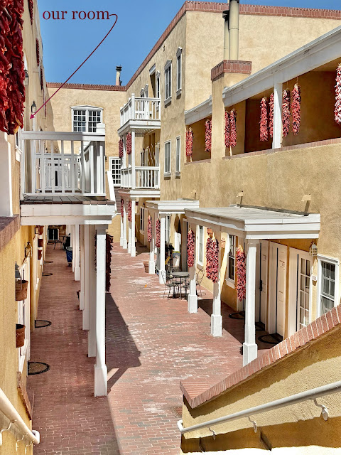
Hotel Chimayo, Washington Ave, Santa Fe.

It still being shoulder season, the hotel had us park the van right in front for our entire stay. (Fortunately we washed our rather filthy van first upon entering Santa Fe.)
We walked everywhere for three days, which in Santa Fe never gets old.

Braided chiles adorn the entire town.

Our 2nd floor room.


Room decor reflected history & culture.

New Mexico Museum of Art.


San Miguel Chapel, built on top of former Indian dwellings.
San Miguel was built around 1610 by Tlaxcalan Indians from Mexico under the "direction" of padres. Several repairs and additions followed, the last the stone buttresses added for support in 1887.


A welcoming courtyard for entry & exit, conversation & contemplation.

Altar & views to original Indian dwelling & sanctuary floors below.


Looking from front to back.

Dwellings next to San Miguel.
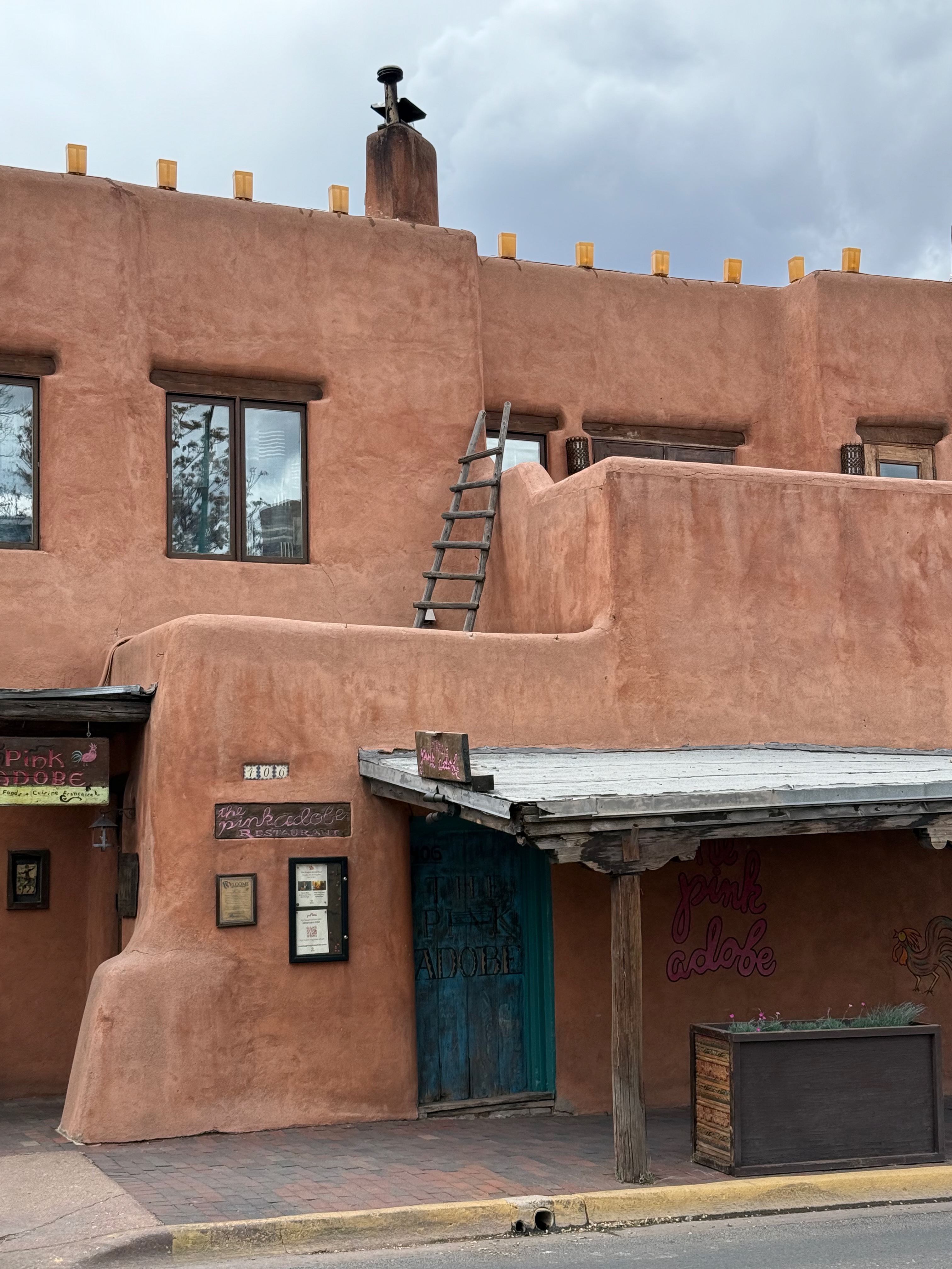
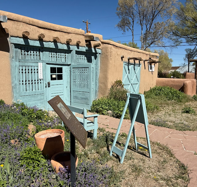
The Pink Adobe Restaurant on Old Santa Fe Trail.

Doug did a walking tour that was very informative, including the story of Loretto Chapel's staircase. The chapel for the Sisters of Loretto was under construction in the late 19th century when the bishop in charge died. There was no staircase to the loft. With no money at their disposal, the sisters prayed. A stranger showed up and built a staircase of wood not from the area. It was 20-feet tall, had no nails or center support, and included two 360-degree spirals. The stranger disappeared without being paid.

A railing was added after the sisters spent a decade going up and down the stairs on hands and knees so as not to trip in their long habits. To this day, historians, architects, and physicists are amazed by the design, and none can comprehend how it could have been built with no power tools.

Santa Fe Village.


Cathedral Parish office.

Even the parking garages fit the architectural style.
.jpeg)
.jpeg)
Columns at front of IAIA painted by students.

Hotel Chimayo is steps from the Portal of the Palace of Governors on the Plaza where Native Americans sell their art.

Marilyn deciding on earrings. Doug only bought her three gorgeous pair in Santa Fe.

"De colores, de colores son los pajaritos que vienen de afuera..." (“Colors, colors of the little birds that come from outside.…” Trad. folk song.)

Our best dinner was at Pantry Rio.

Traditional architecture.

To go in or out?

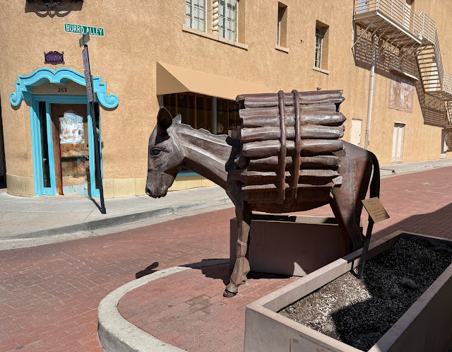
Burro Alley was where farmers & merchants unloaded goods from their burros to sell.

Worrel Gallery, Santa Fe, down the street from Hotel Chimayo.

Alameda Stormwater Rain Garden diverts runoff to put it to use in & beautify the urban landscape & eventually purify the water that accumulates underground.

Covid-19 Memorial Garden in front of Cathedral "dedicated to those who lost their lives, we who mourn, and all those who served them."

Another small fountain, Worrel Gallery.
If only we could import the wonderful water features we saw on our trip to our yard....
 Palace Ave around the corner from our hotel.
The Rainbow Man on Palace Ave. Doug cannot get enough of this place. First the art, so many beautiful pieces. Then, on the walls, an amazing collection of Edward Curtis's original photographs of Native Americans.

In the back is the Santa Fe office of Robert Oppenheimer. This is where new hires for the Manhattan Project were processed.

Finally, a place to find nice pottery, which we are proud to show off to those who visit our back yard.
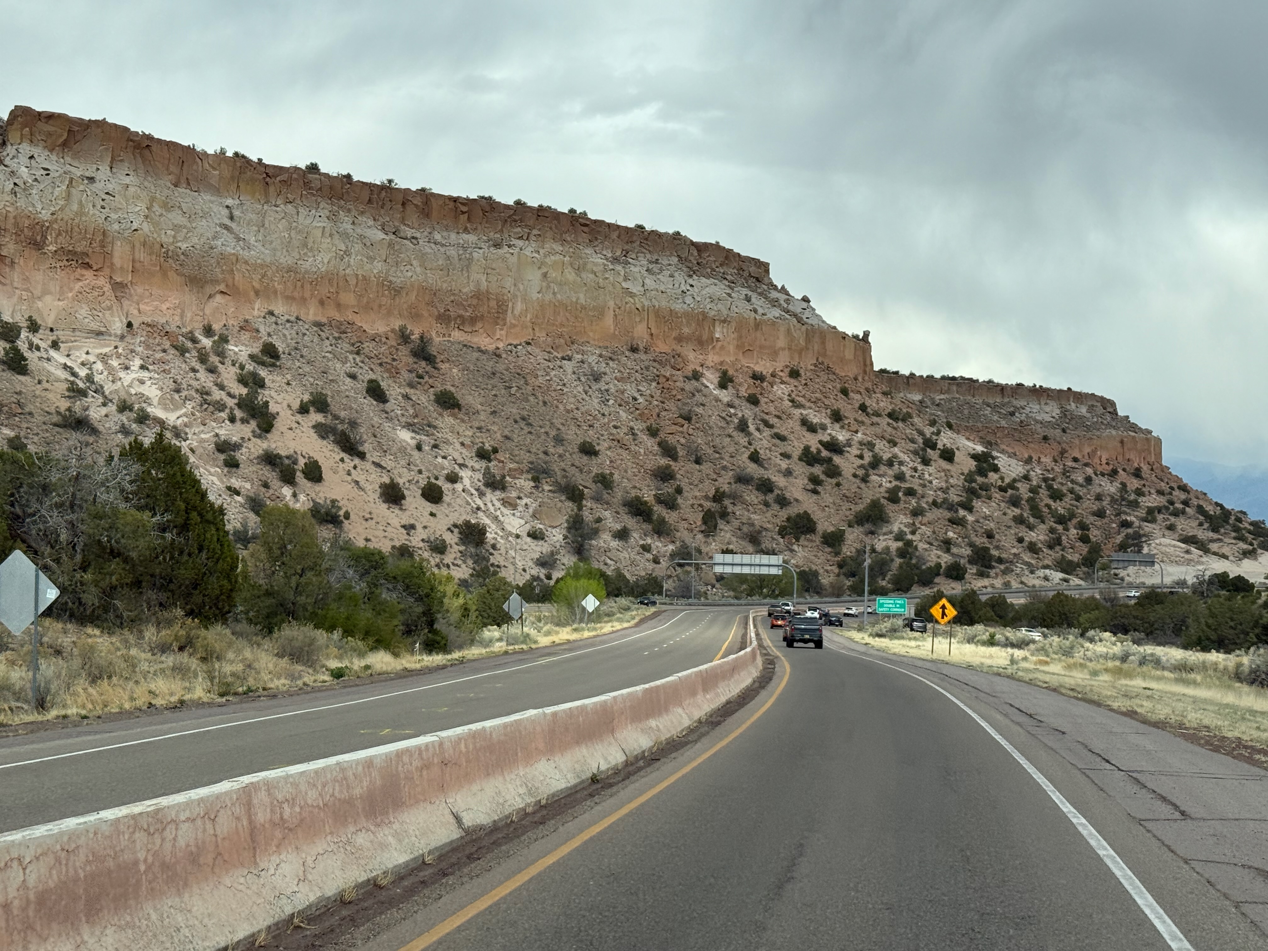
En route to Taos we climbed the steep road from the Rio Grande to the top of Pajarito Plateau & Los Alamos, an elevation gain of almost 6,000 feet.
The Manhattan Project National Historical Park is in the three places where the project was worked on: Hanford, Washington; Los Alamos, New Mexico; and Oak Ridge, Tennessee.

The map took us to the Los Alamos History Museum on Bathtub Row (20th St), guest quarters for Los Alamos Ranch School & during the Manhattan Project.
The early-20th century houses of 20th Street, formerly faculty housing of the Los Alamos Ranch School, whose grounds the government purchased, were home to head scientific and military personnel of the Manhattan Project. Housing quickly built for the thousands who moved to Los Alamos to work on the Manhattan Project had only showers, whereas the older 20th Street houses had bathtubs, as well. Thus 20th Street was dubbed “Bathtub Row.” (The "Tub," i.e., Bathtub Row Brewing Coop, is in downtown Los Alamos.)
 Oppenheimer house, Bathtub Row.
 Doug, with his logical, mathematical, scientific brain, delved into the exhibits of Bradbury Museum, but Marilyn unfortunately found the facts and figures overwhelming.


Taos


Map of nuclear safeguards around the world. Greenish-yellow is countries with nuclear facilities under safeguards. Marilyn had no idea so many countries have any nuclear capabilities. Orange is the major players.

Soon it was time to head to Taos. Heading down the steep hill from Pajarito Plateau to the Rio Grande River Valley.

Amazing formations everywhere one looks.
Taos

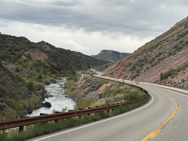
Driving along the Rio Gande.

Entering Taos with Sangre de Cristo Mountains as backdrop.

We returned to the Taos Valley RV Park, where we’d stayed on our last visit, & were not disappointed.

Glorious clouds & sunset.

San Francisco de Assís National Historic Landmark, Taos.

Taos Pueblo Indians spent 40+ years constructing the church for the Franciscans.

A young man photographed the church while we were there, like his famous predecessors Ansel Adams & Georgia O'Keeffe, & many artists since.

St Francis & Doug.

Gift shop mimics the church.

Private residence near church.

Another residence looks abandoned.
Despite knowing its terrifying height from a previous visit, we drove out to the Rio Grande Gorge Bridge.


It may be the most beautiful...

...but it's a long way down: 650 feet. When driving or walking, 1/8 mile is nothing, but when you are looking straight down?

Standing on the bridge looking south...

...& looking north. It is just amazing how water & time have shaped this area.

Doug keeping a safe distance.
We turned back toward Taos then north on the 84-mile Enchanted Circle National Forest Scenic Byway

Enchanted Circle (Hwys 522, 38, 64).

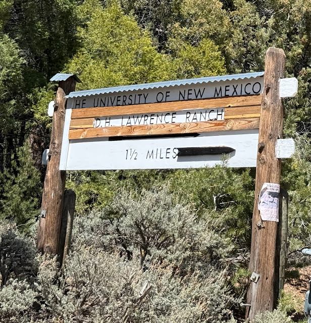
We soon saw signs for the D.H. Lawrence Ranch, which Doug had long wanted to visit. Unfortunately, it was closed that day.

Undeterred, we drove as far as we could on the well-maintained dirt road until conceding defeat—sadly with no views of the abode—at the closed gate to the ranch.
 Meanwhile, we hit 3,000 miles for the 2-1/2 weeks since leaving home—only 3,274 to go, not that we knew that then. We'd spend an additional nearly 4 weeks visiting family & friends & meandering through amazing country.
It's the geology, the formations, that draw us as much as anything when we travel. Good thing, since it was still shoulder season, & the village of Questa's artesans were still in winter mode.

There are mountains of tailings from former molybdenum mining near Questa.
Miners sought gold near Questa in the late 19th century. By 1900, the search switched to molybdenum. A large mining operation owned by Molycorp, then Union Oil, then Chevron, became a Superfund Cleanup Site in 2009 and closed in 2014. Both surface and ground water had been contaminated. Chevron has built a solar farm and in 2025 reached an agreement over water rights with local businesses and communities.

A herd of mountain goats grazed along the road next to the former mine.

A lot of rock has been used to shore up the roadside.

The Southwest mesmerizes.
Back in Taos, we walked along the arcades of the Plaza, built by the Spanish for defense 400 years ago. Marilyn strolled down Ledoux Street and back, taking in the doors, adobes, art, and blues. Originally designed like a fortress with gates at each end, today the area is home to numerous museums.


Spanish Moors traditionally painted doors blue, thinking to repel insects.


In Native American culture, blue is a sacred color and represents the cardinal direction Southwest.

Home with traditional blue door & ladder.


Drains beneath downspouts.

Taos Pueblo (photo taospueblo.com).
Dances and other events took place during the day, and Native American artisans sold their creations at booths and in their homes. Marilyn bought another pair of earrings.
Taos Pueblo has been continuously inhabited for over 1,000 years. Spanish explorers arriving in the 16th century believed the pueblo to be made of gold—it was micca in the clay used to build the adobes that glinted in the sunlight.
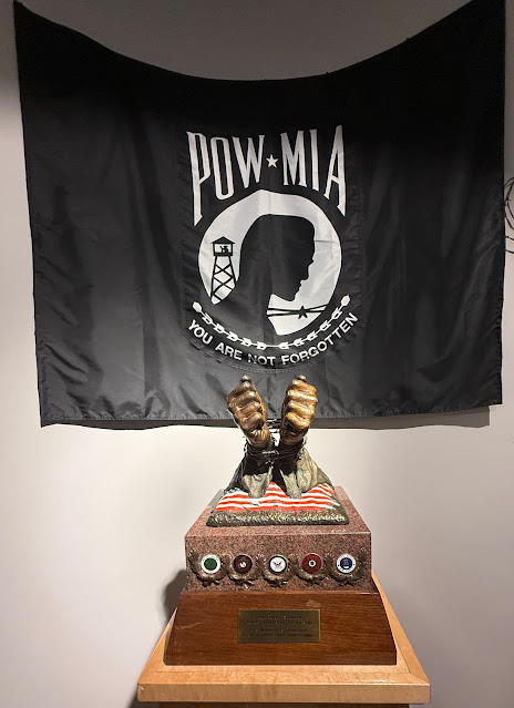
Vietnam Veterans Memorial, Angel Fire
On our way north from Taos, we stopped in Angel Fire at the Vietnam Veterans Memorial. As Doug is a Vietnam Vet, a Navy "helo driver," it was something he wished to visit.
.jpeg)
Chapel, open 24/7.
Dedicated in 1971, the Vietnam Veterans Peace and Brotherhood Chapel was built by Victor and Jeanne Westphall to honor their son, David, and the 15 other men in his squadron who were killed in Vietnam in 1968.
.jpeg)
Huey helicopter flown in Vietnam.
The memorial inspired the Vietnam Veterans Memorial Wall in Washington DC, completed in 1982.

Over the years, 25 acres have been added to the Angel Fire memorial. A Visitors Center built into the hillside so as to be unobtrusive is next to the chapel. A cemetery is in the valley below. The memorial is now owned by the State of New Mexico and known as Vietnam Veterans Memorial State Park.

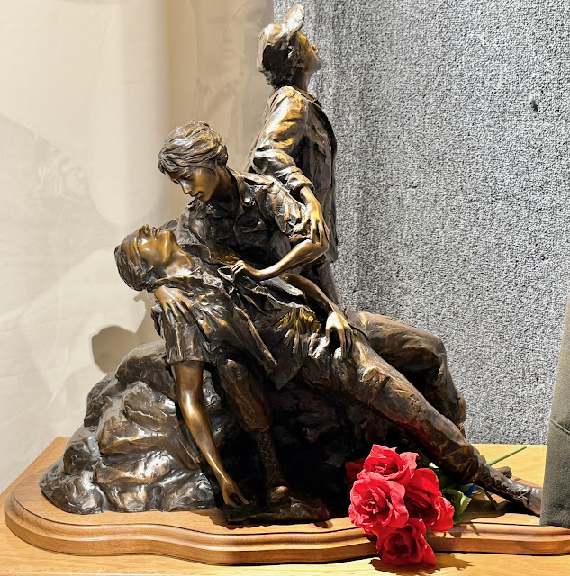
Original scale model of Vietnam Women's Memorial, completed in Washington DC in 1993, Glenna Goodacre, 1990.
.jpeg) Amphitheater.
Amphitheater..jpeg) Chapel interior, a sliver of light open to cemetery in valley below.
Chapel interior, a sliver of light open to cemetery in valley below..jpeg)
The Veterans Memorial Cemetery in valley below Chapel.
Leaving New Mexico, our original plan was to head to Durango, Colorado, then north to Silverton and Ouray, but Mother Nature said otherwise. We really did not need to spend the next week navigating snow, so we headed instead to the Boulder/Denver area to visit family and friends. We would also have the van's electric system worked on by VanWorks in Fort Collins. Once again we toasted our Elastic Itinerary mentality.
Southwest 2025-5: 7 days/420 mi
.jpeg)
Our entire Southwest 2025 trip: 6.5 weeks/6,274 mi.
 Southwest 2025: 6-1/2 weeks. 6,273.5 miles. (1) Visalia CA-Green River UT. (2) Green River-Ship Rock NM. (3) Ship Rock-Aldo Leopold Wilderness. (4) Leopold-Carrizozo. (5) Carrizozo-Taos. (6) Taos-Salida CO. (7) Salida-Green River UT. (8) Green River-Kanab. (9) Kanab-Kanab. (10) Kanab-Bridgeport CA. (11) Bridgeport-Visalia.
Santa Fe is on our list for a detour on the way to Texas some day. Steve
ReplyDeleteAn excellent detour to make😎
DeleteThank you for the nice visit! This is a part I wished to do on my last trip, but time and weather were not on my side. P.S. I wonder how many earrings Marilyn must have by now ; )
ReplyDeleteIl faut y aller❣️ J’en ai trop😎
Delete