Southwest 2025-4: New Mexico: Las Cruces, Aguirre Springs, White Sands, Valley of Fires, Carrizozo
April 26-27, 2025

From White Sands we were off to a favorite spot: Valley of Fires BLM Campground and nearby Carrizozo.


We've walked the trail through Malpais Lava Flow just over next to the campground, but the heat and wind made that undesirable this time.

The Malpais Lava Flow, 4 to 6 miles wide and 160 feet thick, formed 5,000 years ago when Little Black Peak erupted. The flow covered 44 miles.
Carrizozo History Lesson
The railroad, outlaws, and politics, including a local senator's losing his ranch due to his involvement in the the Teapot Dome Scandal, have played in Carrizozo's history. As well as providing transportation for cattle ranchers and miners, the arrival of the railroad in the late 19th century led to homesteading and tourism. The town's population peaked at 2,000 in 1920. The automobile took the tourists and the railroad away in the 1950s. Today the population is under 1,000.


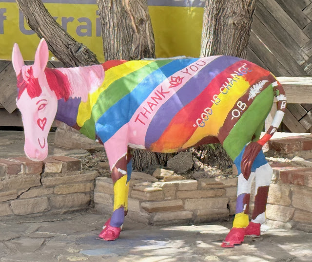
Doug soon found himself seeking the burros for which Carrizozo is known for Marilyn to photo. Some had received a refresher or new style since our last visit.


 .
. 


 Southwest 2025: 6-1/2 weeks. 6,273.5 miles. (1) Visalia CA-Green River UT. (2) Green River-Ship Rock NM. (3) Ship Rock-Aldo Leopold Wilderness. (4) Leopold-Carrizozo. (5) Carrizozo-Taos. (6) Taos-Grand Villa CO. (7) Grand Villa-Green River UT. (8) Green River-Kanab. (9) Kanab-Kanab. (10) Kanab-Bridgeport CA. (11) Bridgeport-Visalia.
We left the cold, windy Aldo Leopold Overlook headed for Las Cruces. The town looked so appealing after days in small towns. Being a weekend, we figured camping at the local Cracker Barrel, as we've done elsewhere, would work fine. Plus there'd be the wonderful (cholesterol-laiden) breakfast in the morning! Doug was ready for his annual Biscuits and Gravy....


Well, on the way to White Sands, we passed the turn-off to Aguirre Springs. Marilyn said there might be a campsite available.... Doug laughed but did a U-turn. A dirt road curved up the side of the hill to the campground where—most of the sites were empty! Yep, Marilyn saved the day. We got a campsite and put off White Sands until Sunday. But sadly, there were no biscuits and gravy, and Las Cruces remains on the as-yet-to-visit list.


The park is at 4,235 feet. The San Andres Mountains to the west average 7,000 to 8,000 feet, with the highest peak just under 9,000. To the east are the Sacramento Mountains, averaging 8,000 to 10,000 feet with the highest peak just over 12,000 feet.

The sand is actually gypsum left behind by the ancient Permian Sea. Winds blow the gypsum into new shapes and dunes as high as 60 feet, but water a few inches below the surface keeps it from blowing away.


We didn't see any animals. In fact, their colors have evolved so that they blend in with the environment. The park brochure has pictures of the bleached earless lizard and Apache pocket mouse which are much lighter than their family who live elsewhere in the Chihuahuan Desert. As in other deserts, animals also tend to emerge at night, when it's cooler.


There are trails, but it appeared to us it would be very difficult to follow them. Plus, there is no shade or water on the trails. Indeed, people have died hiking White Sands and dozens of search & rescue missions occur each year.

White Sands National Park spreads across Tularosa Basin to mountains east & west.
As we'd arrived in Las Cruces early, we decided to head to White Sands and then return. On Sunday we'd eat early and head to FCFS (first come first serve) Aguirre Springs Campground, which Stephen and Jessie, Marilyn's son and bonus daughter, raved about. Hopefully someone would be leaving and we could snag a site. Thus we had a plan—well, about as close as we ever get to a plan.

White Sands National Park, the white line in the distance, from Aguirre Springs.
Well, on the way to White Sands, we passed the turn-off to Aguirre Springs. Marilyn said there might be a campsite available.... Doug laughed but did a U-turn. A dirt road curved up the side of the hill to the campground where—most of the sites were empty! Yep, Marilyn saved the day. We got a campsite and put off White Sands until Sunday. But sadly, there were no biscuits and gravy, and Las Cruces remains on the as-yet-to-visit list.

The perfect site.
We stopped at the top of the campground to check out sites & entered into an enjoble conversation with a couple from New Jersey, via Kenya & France. It turned out they were packing up to leave in their Promaster similar to ours, so as soon as they pulled out, we backed in.

White Sands could wait a day.

The Organ Mountains are backdrop to 5,000-foot-elevation Aguirre Springs.

It was warm, so we opened the van & turned on the fans.

We heard the distinctive call of quail & spotted a covey with male guard.

The next morning we were off to White Sands NP. The park is within White Sands Missile Range. Both park & US 70 are closed during testing.

White Sands' low adobe buildings—here the park's Administrative Office—are perfect to the surroundings.

Having grown up with snowy winters, Marilyn immediately commented that the sand looks like snow.

The park is at 4,235 feet. The San Andres Mountains to the west average 7,000 to 8,000 feet, with the highest peak just under 9,000. To the east are the Sacramento Mountains, averaging 8,000 to 10,000 feet with the highest peak just over 12,000 feet.

The sand is actually gypsum left behind by the ancient Permian Sea. Winds blow the gypsum into new shapes and dunes as high as 60 feet, but water a few inches below the surface keeps it from blowing away.

And with water, there are plants.

We didn't see any animals. In fact, their colors have evolved so that they blend in with the environment. The park brochure has pictures of the bleached earless lizard and Apache pocket mouse which are much lighter than their family who live elsewhere in the Chihuahuan Desert. As in other deserts, animals also tend to emerge at night, when it's cooler.

Huge parking lots are kept plowed, looking like a sheet of ice.

Picnic tables sheltered from sun & wind.
Lots of folks brought their snowboards, saucers, & sleds to glide down the slopes.

We were walking to the top of the hill: distance was difficult to determine & it was essential to keep an eye on where we'd come from.
There are trails, but it appeared to us it would be very difficult to follow them. Plus, there is no shade or water on the trails. Indeed, people have died hiking White Sands and dozens of search & rescue missions occur each year.

Sign at White Sands Trailhead.
White Sands National Park.

The wind driving north to Carrizozo was a bit interesting (Doug-speak for Grrrr): a steady 30 mph & gusting to over 50 coming from our left side.

The sky was brown.

We'd previously toured the sites of the Billy the Kid National Scenic Byway loop east of Carrizozo in Lincoln County, NM.


Though our favorite spacious site on a secluded bluff was available, we opted to camp lower to avoid at least some of the wind.

Wind-blown style—not quite the same as with a hair dryer.
We've walked the trail through Malpais Lava Flow just over next to the campground, but the heat and wind made that undesirable this time.

A strange landscape with plants growing out of lava.
The Malpais Lava Flow, 4 to 6 miles wide and 160 feet thick, formed 5,000 years ago when Little Black Peak erupted. The flow covered 44 miles.
Carrizozo History Lesson
The railroad, outlaws, and politics, including a local senator's losing his ranch due to his involvement in the the Teapot Dome Scandal, have played in Carrizozo's history. As well as providing transportation for cattle ranchers and miners, the arrival of the railroad in the late 19th century led to homesteading and tourism. The town's population peaked at 2,000 in 1920. The automobile took the tourists and the railroad away in the 1950s. Today the population is under 1,000.

The downtown is aptly described as "discernible" on the town history marker. Some buildings indicate renovation since our last visit 2021.

Other buildings show perhaps an attempt at renovation. The wonderful bright colors are so typical of the Southwest.

A few historic buildings remain, including the Carrrizozo Woman's Club.

Established in 1920, the Carrizozo Woman's Club received a new Pueblo Revival Style building under the Works Progress Administration in 1939.

The building is on the National Register of Historic Places.
Doug soon found himself seeking the burros for which Carrizozo is known for Marilyn to photo. Some had received a refresher or new style since our last visit.


 .
. 
Even the police station has its own burro.


A courtyard of burros.

Wind blowing this wonderful thin brass rectangle hung from two stories up rippled the water in the small pool.


Southwest 2025-4: 2 days/286 mi

We did not visit the Karl G. Jansky Very Large Array National Radio Astronomy Observatory this time, but wanted it on the map, as should you go that way, it is fascinating.
Our entire Southwest 2025 trip: 6.5 weeks/6,274 mi.
 Southwest 2025: 6-1/2 weeks. 6,273.5 miles. (1) Visalia CA-Green River UT. (2) Green River-Ship Rock NM. (3) Ship Rock-Aldo Leopold Wilderness. (4) Leopold-Carrizozo. (5) Carrizozo-Taos. (6) Taos-Grand Villa CO. (7) Grand Villa-Green River UT. (8) Green River-Kanab. (9) Kanab-Kanab. (10) Kanab-Bridgeport CA. (11) Bridgeport-Visalia.
Coming up: Santa Fe, Rio Grande Gorge, Taos.
I had no idea that White Sands was so truly WHITE—and that it wasn’t really sand.
ReplyDeleteAny rate, surfing a gypsum dune; who’d a-thunk it?
Reminded me of the quartz beach on Florida Gulf Coast.
Delete