Hoopetedoodle : Klamath River & Basin, the Lost Coast, Boonville
Sometimes one of us—usually Marilyn—decides to delve into the whys and wherefores of places we’ve been. In Steinbeck’s Sweet Thursday, Mack calls this “hooptedoodle” and says it does not belong in the story proper (quote in sidebar).

From Lava Beds, we passed through Klamath Falls, named for the Klamath River spilling over falls as it rolls through town. Toward the end of our trip, we crossed the Klamath River again, on US 101 near its mouth on the Pacific.

The Klamath has been called a "river upside down." Most rivers begin in mountain wilderness and flow toward urban centers, but the Klamath flows from an urban/agricultural high desert area into mountains and through rainforest on its 260-mile meander to the Pacific Ocean.

After both world wars, homesteading was further encouraged through a lottery. Each winning veteran received a plot of land in the Tule Lake Basin.


About 80 percent of migratory birds on the Pacific Flyway stop in the Klamath Basin, a fact that was ignored when the Klamath Project was begun. Once cognizant of this, the government created Lower Klamath Lake National Wildlife Refuge in 1908, Clear Lake NWR in 1911, Upper Klamath NWR and Tule Lake NWR in 1928. By that time, Tule Lake had been reduced from 100,000 acres to 13,000. Klamath Marsh NWR in 1958 and Bear Valley NWR in 1978 completed the Klamath Basin National Wildlife Refuge Complex.

In the wake of the 2001 drought, conflict increased among tribes, farmers, fishermen, local governments, and ecologists over use of the Klamath River. For Native Americans, not only is the Klamath Basin their home, livelihood, and transportation, but it is essential to their culture.

In 2002, to protect salmon, water for irrigation was curtailed. Later, to appease farmers, water was restored. The sudden rush of water led to the death of tens of thousands of salmon, both adults swimming upriver to spawn and juveniles swimming downriver to the ocean.

In 2010, after years of wrangling, tribes, farmers, fishermen, and conservationists signed two water rights agreements. Included was a planned study by the Department of the Interior on the removal of four dams on the Klamath. The plan was not officially agreed to until 2016, with removal to be completed by 2020. That did not happen, due to questions about liability and cost overruns raised by US regulators.

Conflict again intensified in 2021, due to dam removal being delayed and another drought showing no end in sight. These issues were finally resolved by an infusion of funds from California, Oregon, and PacifiCorp, the dams’ operator. In June of 2023, removal of the first dam, Copco No 2, began, with a projected completion date of summer 2024 for the removal of all four dams.
.jpeg)
More than anything, building Hwy 1 along the Lost Coast would require excavating mountains that climb nearly straight up to 4,000 feet and that are prone to slides. Daunting, to say the least.

Only about 15 years after becoming a major industry, in the late 1930s, the San Francisco Fish Company ceased operations in Shelter Cove. The wharf subsequently fell into disrepair. With no shipping facilities, other industries declined. A decrease in population followed. This series of events leading to an exodus of those who'd lost their livelihood, according to Mario Machi in his book Gem of the Lost Coast, is the real reason the area became known as the Lost Coast.

Fishermen in San Francisco, brothers Mario, Tony, and Babe Machi spent summers in the 1930s fishing in Shelter Cove. During World War II, the Coast Guard had a base in Shelter Cove as part of Coastal Defense. Mario Machi fought overseas, was captured, forced on the Bata’an Death March, and imprisoned. He would later say that memories of Shelter Cove helped keep him alive. After the war, he worked as a teacher and school bus driver to make money to buy land in Shelter Cove.
The Machi brothers eventually did move to Shelter Cove, where they operated the marina and a hotel. They are credited with helping to revive the town. Today Shelter Cove has about 700 residents. The area is largely a vacation and second-home destination, with an airstrip to facilitate travel.

Back to our 2003 trip. We drove north on Hwy 1 from Bodega Bay, where Marilyn's parents had retired. While pumping gas in Garberville, a few miles north of Leggett, Doug noticed a sign for the Lost Coast. In a quick consult we decided, Why not? and were off on another adventure.

Cape Mendocino Lighthouse, several miles to the north, predated Punta Gorda, starting operation in 1868. Both ships and lighthouse keepers faced treacherous conditions from frequent storms and earthquakes. The Coast Guard ran the lighthouse during WWII, after which it was automated. Later, a beacon was placed on a nearby cliff, where it operated until 2013. In 1998, the lighthouse was moved to Shelter Cove.
Back on Mattole Rd, we drove north to Ferndale, a Victorian town reminiscent of Mendocino. Then it was back to 101 and continuing our trip north.

A tad more on Hwy 1: We were headed home in November 2021, at the end of a 6-week meander. As we approached Leggett, Doug said, "101 or 1?" My quick response, "1!" and we were off on the 14 miles of two-lane-no-shoulders road that winds down along the edges of forested river canyons like a drunk cow. This is decidedly not one of Doug’s favorite drives, especially not on a dark and stormy night as we'd done previously.

Doug did, however, try to get to the Lost Coast again, in 2022. Driving home in the VW from Oregon, with a new transmission and an added limited slip (now both rear wheels would work together), he turned off 101 at Fernbridge. He found a dirt road that led to Shelter Cove, but recent rains and a sign warning against traveling it made him think otherwise. He returned to 101, promising himself to return soon.
The closest we've been to the Lost Coast otherwise is dinner at the Lost Coast Brewery in Eureka.
Boonville

We also passed through Boonville on our way home in fall 2021. A pleasant memory of morning coffee in sun-dappled shade, along with my son’s camping and mountain biking in the area, piqued my interest in the town again.

Located in the Anderson Valley, Boonville began in 1862 as the Corners, then Kendall’s City. When a Mr. Boone bought a local hotel, he donated his name to the town.
In around the 1870s, a new language grew among the residents of the isolated farming and logging community. "Boontling" is said to be a combination of English, Scottish Gaelic, Irish, Spanish, Pomoan—the language of the Pomo Tribe, the original inhabitants of the area—and creativity. The websites of the Anderson Valley Museum, Anderson Valley Brewing Company, the Paris Review, and others recount the history of Boontling and contain Boontling glossaries. A few examples:
Boont: Boonville
harp: to speak Boontling
gorm: food, to eat
frattey: wine
jape: to drive a car
Poleeko: Philo, a town near Boonville
.jpeg)
There are a number of theories as to the origins of Boontling, all involving a desire for secret conversations: children wanting to prevent their parents from understanding what they were saying; women wanting to gossip in private while working the hop fields; men wanting to speak about topics such as sex—concerning which there are a rather large number of words in the dialect.

On the practical side, WWI soldiers were said to have used Boontling to get messages home past censors, and sports teams used it to confuse their opponents. Boontling was once taught in the local school. Some words have entered the popular culture, and Boontling language and history are preserved in print, but with Boonville’s current population at around 1,000, only about 12 of whom actively speak Boontling, the language is at risk of disappearing as an oral tradition.
.jpeg)
Besides Boontling, Boonville is known today for wineries, the Mendocino County Fair and Apple Show, including sheep dog trials, the Sierra Nevada World Music Festival, and the Boonville Beer Festival.

Well, that’s enough hoopetedoodle for now. Bahl’ hornin’! Cheers!
A few Klamath River Basin sources
Andrews, Jessica Cejnar. "Klamath River Dam Removal Project Commences; KRRC Says Construction Crews Will Have Copco No. 2 Out In September." Wild Rivers Outpost, June 23, 2023. wildrivers.lostcoastoutpost.com/2023/jun/23/klamath-river-dam-removal-project-commences-krrc-s/
"Case Study: Klamath Basin." National Geographic. education.nationalgeographic.org/resource/case-study-klamath-basin/
Fisher, Konrad. "The Klamath River’s advocates succeed on their second try with new agreement for largest-ever dam removal." Waterkeeper. Water Alliance, Vol 13, Issue 1, Winter 2001. waterkeeper.org/magazines/volume-13-issue-1/klamath-river-dam-removal/
https://education.nationalgeographic.org/resource/case-study-klamath-basin/
Graber, Brian. “Five Key Lessons as World’s Biggest Dam Removal Project Will Soon Begin on the Klamath River.” American Rivers, Nov 17, 2022.
americanrivers.org/2022/11/five-key-lessons-as-worlds-biggest-dam-removal-project-will-soon-begin-on-the-klamath-river/#:~:text=PacifiCorp%20originally%20agreed%20in%20principle,River%20Renewal%20Corporation%20(KRRC).
Henshaw, Melanie. “Unnatural conflict in Klamath Basin: Conflicting interests in ongoing Klamath Basin water crisis forces difficult choices.” Street Roots, Feb 1, 2023. streetroots.org/news/2023/02/01/conflict-klamath-basin
"Klamath Basin." Wikipedia. en.wikipedia.org/wiki/Klamath_Basin
"Klamath Basin Dam Removal: 2001–2024." sustainablenorthwest.org/klamath-basin-dam-removal-history
"Klamath Basin National Wildlife Refuges." oregonwild.org/waters/klamath/refuges
"Klamath River." American Rivers. https://www.americanrivers.org/river/klamath-river/
"Klamath River Basin." Water Education Foundation. watereducation.org/aquapedia/klamath-river-basin
Most, Stephen. "Klamath Basin Project (1906)." oregonencyclopedia.org/articles/klamath_basin_project_1906_/
Peterson, Molly. "Removal of Klamath Dams Would Be Largest River Restoration in U.S. History." Oct 24, 2016.
kqed.org/news/11133820/removal-of-klamath-dams-would-be-largest-river-restoration-in-u-s-history
"Places We Protect: Lower Klamath Basin, California." The Nature Conservancy. nature.org/en-us/get-involved/how-to-help/places-we-protect/lower-klamath-basin/
"Reclaiming the Klamath." Earth Justice, Nov 23, 2020. earthjustice.org/feature/klamath-salmon-yurok-tribe
Ryner, Russ."Reuniting a River." National Geographic, Dec 2008. people.wou.edu/~taylors/g473/NGS_klamath_Dec_2008.pdf
"The Klamath River." oregonwild.org/waters/klamath/the-klamath-river
Herewith, some hooopetedoodle Marilyn has been investigating: the Klamath Basin, the Lost Coast, Boonville.

Klamath River (photo, Matt Baun/USFWS).
.jpeg)
Klamath River & Basin
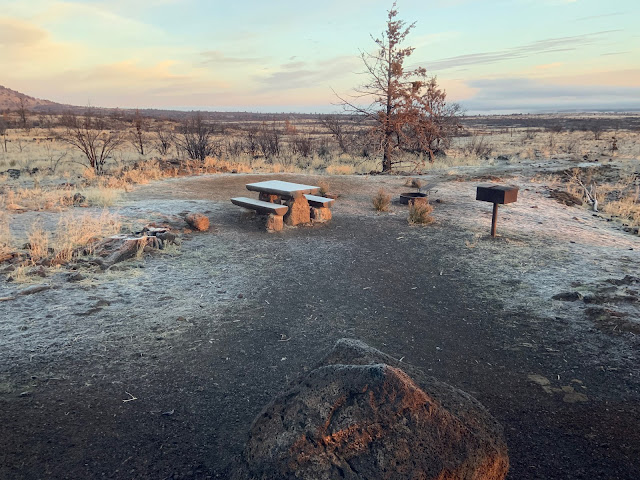
On our fall 2021 trip we camped at Lava Beds National Monument in the Southern Cascade Mountains in northeastern California. We were just south of the Tule Lake National Wildlife Refuge, the town of Tulelake, and the Oregon border. Lava Beds sits on the slightly sloped side of Medicine Lake Volcano, a shield volcano, at around 4,000 feet in high desert.
On our fall 2021 trip we camped at Lava Beds National Monument in the Southern Cascade Mountains in northeastern California. We were just south of the Tule Lake National Wildlife Refuge, the town of Tulelake, and the Oregon border. Lava Beds sits on the slightly sloped side of Medicine Lake Volcano, a shield volcano, at around 4,000 feet in high desert.

Lava Beds National Monument campsite, Oct 2021. It was cold! Two wildfires in recent years had burned the majority of the monument.
From Lava Beds, we passed through Klamath Falls, named for the Klamath River spilling over falls as it rolls through town. Toward the end of our trip, we crossed the Klamath River again, on US 101 near its mouth on the Pacific.

Klamath River Upper & Lower Basins are in darker green.
The Klamath has been called a "river upside down." Most rivers begin in mountain wilderness and flow toward urban centers, but the Klamath flows from an urban/agricultural high desert area into mountains and through rainforest on its 260-mile meander to the Pacific Ocean.

Klamath River (photo, Anne Murveit, KRRC).
Native American tribes and wildlife have inhabited and sustained themselves by the rivers, lakes, marshes, and wetlands of the 12,000-square-mile Klamath River Basin for thousands of years. The Modoc plied Tule Lake, then one of the largest in the basin, in dugout canoes carved from logs and canoes constructed of bundles of tule stalks.
 Modoc dugout canoe of Jennie Clinton, the last survivor of the Modoc War (photo, Lava Beds Visitor Center).
White settlers began to arrive in the Klamath Basin in the late 1870s, looking to use the land for livestock and agriculture. To them, this necessitated forcing out Native Americans, which led to the Modoc War. A mere 53 Modoc warriors and their families, led by Modoc Chief Captain Jack, maintained a 5-month-long standoff with 650 US soldiers. Ultimately, Captain Jack was "tried" and hanged, and the remaining Modoc were forced onto arid land in Oklahoma. Survivors were not permitted to return to the Klamath Basin until 1909. As one so often asks when looking at US history, why did a people need permission to return to their own lands?

In 1902, to entice more settlers to the Klamath Basin, the US government created the Reclamation Service (today the Bureau of Reclamation) to “reclaim” land for farming, i.e., drain lakes and wetlands and direct water via canals, tunnels, levees, and dams. In 1906, the USRC began the Klamath Basin Project. The first 2 of an eventual 6 dams to store and control water were built on the Klamath River in 1918 and 1921.

 Modoc dugout canoe of Jennie Clinton, the last survivor of the Modoc War (photo, Lava Beds Visitor Center).
White settlers began to arrive in the Klamath Basin in the late 1870s, looking to use the land for livestock and agriculture. To them, this necessitated forcing out Native Americans, which led to the Modoc War. A mere 53 Modoc warriors and their families, led by Modoc Chief Captain Jack, maintained a 5-month-long standoff with 650 US soldiers. Ultimately, Captain Jack was "tried" and hanged, and the remaining Modoc were forced onto arid land in Oklahoma. Survivors were not permitted to return to the Klamath Basin until 1909. As one so often asks when looking at US history, why did a people need permission to return to their own lands?

Modern-day Modoc canoe built in the traditional manner of bundling tule stalks (photo, Lava Beds Visitor Center).
In 1902, to entice more settlers to the Klamath Basin, the US government created the Reclamation Service (today the Bureau of Reclamation) to “reclaim” land for farming, i.e., drain lakes and wetlands and direct water via canals, tunnels, levees, and dams. In 1906, the USRC began the Klamath Basin Project. The first 2 of an eventual 6 dams to store and control water were built on the Klamath River in 1918 and 1921.

Copco 1, the 1st dam built on the Klamath River, in 1918 (photo, Molly Peterson, KQED).
After both world wars, homesteading was further encouraged through a lottery. Each winning veteran received a plot of land in the Tule Lake Basin.

Tule Lake National Monument, the former Japanese-American Internment Camp of World War II, today.
During World War II, Tule Lake Internment Camp for Japanese-Americans was thrown up on the east side of the lake bottom. After the WWII lottery, much of the camp, including the cemetery, was bulldozed for more housing, farmland, and an airstrip, without concern for the camp's historical importance and lessons.


In the wake of the 2001 drought, conflict increased among tribes, farmers, fishermen, local governments, and ecologists over use of the Klamath River. For Native Americans, not only is the Klamath Basin their home, livelihood, and transportation, but it is essential to their culture.

Karuk tribal members use traditional dip nets to catch salmon at Ishi Pishi Falls on the mid-Klamath River (photo, Karuk Tribe Fisheries Department).
In 2002, to protect salmon, water for irrigation was curtailed. Later, to appease farmers, water was restored. The sudden rush of water led to the death of tens of thousands of salmon, both adults swimming upriver to spawn and juveniles swimming downriver to the ocean.

Salmon swimming upstream in Klamath River to spawn (photo, Mid-Klamath Watershed Council).
In 2010, after years of wrangling, tribes, farmers, fishermen, and conservationists signed two water rights agreements. Included was a planned study by the Department of the Interior on the removal of four dams on the Klamath. The plan was not officially agreed to until 2016, with removal to be completed by 2020. That did not happen, due to questions about liability and cost overruns raised by US regulators.

Removal of Copco No 2 Dam from Klamath River, July 2023 (photo, Shane Anderson, Swiftwater Films).
Conflict again intensified in 2021, due to dam removal being delayed and another drought showing no end in sight. These issues were finally resolved by an infusion of funds from California, Oregon, and PacifiCorp, the dams’ operator. In June of 2023, removal of the first dam, Copco No 2, began, with a projected completion date of summer 2024 for the removal of all four dams.
"Kamath Basin Dam Removal" is an excellent summary of the history of conflict, agreement, progress, and resolution in the restoration the Klamath River.

Back to our fall 2021 trip. About 40 miles south of the Oregon-California Stateline, traveling US 101, the "Redwood Highway," we crossed the Klamath River Bridge, with its two golden bears flanking each end. There is a story, perhaps a folktale, that in the 1950s some Klamath townsfolk began to paint the bears on the original bridge gold. Each time the highway department removed the paint, the bears turned up gold again soon thereafter. Thus the new bridge was built with gold bears, in deference to tradition.

A little over a mile downriver, concrete bears flank the remains of the first Klamath River bridge, the Douglas Memorial Bridge.

A huge log jam slammed through Douglas Memorial Bridge in the Christmas 1964 flood. Likewise, the flood destroyed the town of Klamath. When the town was moved upstream, it was built 1,000 feet higher than the original town.

Klamath River viewed from remains of Douglas Memorial Bridge upstream from the Pacific Ocean.
Back to our fall 2021 trip. About 40 miles south of the Oregon-California Stateline, traveling US 101, the "Redwood Highway," we crossed the Klamath River Bridge, with its two golden bears flanking each end. There is a story, perhaps a folktale, that in the 1950s some Klamath townsfolk began to paint the bears on the original bridge gold. Each time the highway department removed the paint, the bears turned up gold again soon thereafter. Thus the new bridge was built with gold bears, in deference to tradition.

Bear on approach to Klamath River Bridge, US 101.
A little over a mile downriver, concrete bears flank the remains of the first Klamath River bridge, the Douglas Memorial Bridge.

Concrete bears guard remains of Douglas Memorial Bridge.
A huge log jam slammed through Douglas Memorial Bridge in the Christmas 1964 flood. Likewise, the flood destroyed the town of Klamath. When the town was moved upstream, it was built 1,000 feet higher than the original town.

We much prefer the concrete bears to their gold counterparts.
Until the new bridge was finished upstream, a pile structure made the old bridge functional. Along with a ferry, it carried 101 traffic across the river.

My attempt to understand the Klamath River Basin is a drastic oversimplification of extremely complicated issues going back at least 150 years. Suffice it to say, we humans need to take the long view more often than not.
At the end of this post are sources I read or skimmed—but a slice of all the information that is available.

The Lost Coast

During a recent purge of our travel files, I was surprised to find a misfiled 2009 San Francisco Chronicle article, "Go now: The Lost Coast." Perhaps I'd saved it because we'd traveled to the Lost Coast in 2003 and have talked of going there again.
More recently, my younger son has camped at Usal Beach on the south end of the Lost Coast.

He has the requisite 4WD vehicle for the 6-mile-long dirt road off Hwy 1 from near Rockport to Usal.

Why is this section of California coastline named the Lost Coast? It's often said the label derives from California's famous coast-hugging Hwy 1 turning inland where this section of coastline begins, rather than continuing along the cliffs overlooking the Pacific.

The construction of the 656 miles of Hwy 1 from Dana Point to Leggett took place in stages, beginning in 1911 with a locally funded stretch between Santa Barbara and Ventura. It was completed in 1937, with the exception of the final section from Rockport to Leggett. It was a road of sorts but did not receive the Hwy 1 designation until 1957. The new label brought much-needed improvements to culverts and bridges along this section of highway.

Remains of Douglas Memorial Bridge over Klamath River after Christmas 1964 flood (photo, Greg Rumney).
My attempt to understand the Klamath River Basin is a drastic oversimplification of extremely complicated issues going back at least 150 years. Suffice it to say, we humans need to take the long view more often than not.
At the end of this post are sources I read or skimmed—but a slice of all the information that is available.

The Lost Coast

Lost Coast, 2003...we think: we failed to label our prints--it was pre-phone-camera days.
During a recent purge of our travel files, I was surprised to find a misfiled 2009 San Francisco Chronicle article, "Go now: The Lost Coast." Perhaps I'd saved it because we'd traveled to the Lost Coast in 2003 and have talked of going there again.
More recently, my younger son has camped at Usal Beach on the south end of the Lost Coast.

He has the requisite 4WD vehicle for the 6-mile-long dirt road off Hwy 1 from near Rockport to Usal.

Beginning of 4WD Road from Hwy 1 to Usal Beach at southern end of Lost Coast.
Why is this section of California coastline named the Lost Coast? It's often said the label derives from California's famous coast-hugging Hwy 1 turning inland where this section of coastline begins, rather than continuing along the cliffs overlooking the Pacific.

The construction of the 656 miles of Hwy 1 from Dana Point to Leggett took place in stages, beginning in 1911 with a locally funded stretch between Santa Barbara and Ventura. It was completed in 1937, with the exception of the final section from Rockport to Leggett. It was a road of sorts but did not receive the Hwy 1 designation until 1957. The new label brought much-needed improvements to culverts and bridges along this section of highway.
At Leggett, Hwy 1 meets US 101. About 90 miles north, near Eureka, 101 picks up the coast again. The road does not, however, change back to Hwy 1, instead remaining US 101.
It's the area west of 101 between Leggett and Eureka that is known as the "Lost Coast." Articles such as "Paper Highways: California State Route 1 through the Lost Coast (Modern State Route 211),” detail the vicissitudes of Hwy 1 on the Lost Coast. As late as 2005, the Caltrans State Map continued to show Hwy 1 on the Lost Coast as part of unbuilt Hwy 211. There are many conjectures as to why the route was never completed: (a) it would have been next in line after the challenges of Big Sur, when the country was on the verge of joining WWI; (b) it wasn’t a priority after WWII, when the interstate highway system was birthed; (c) the decline of redwood logging meant the end of logging interests seeking an easier route to 101; (d) beginning in the 1970s environmental concerns began to take hold, which led in 1972 to the creation of the California Coastal Commission.
.jpeg)
Lost Coast (map, Janet Young).
More than anything, building Hwy 1 along the Lost Coast would require excavating mountains that climb nearly straight up to 4,000 feet and that are prone to slides. Daunting, to say the least.
But is the lack of Hwy 1 the reason this area of coastline became known as the "Lost Coast"? A little history.
Native Americans of course long inhabited the area by the time white settlers began to arrive in the area of Shelter Cove in the 1850s, in search of grazing land for cattle. By the 1880s, Shelter Cove had become a popular vacation spot, with folks arriving by wagon or steamship. Along with livestock and tourism, around 1925, fishing became a major industry. A wharf and freight buildings were constructed to process and ship fish. Another local industry was the logging of tan oak bark, which was liquefied to a syrupy consistency and shipped in barrels for use in tanneries.
Native Americans of course long inhabited the area by the time white settlers began to arrive in the area of Shelter Cove in the 1850s, in search of grazing land for cattle. By the 1880s, Shelter Cove had become a popular vacation spot, with folks arriving by wagon or steamship. Along with livestock and tourism, around 1925, fishing became a major industry. A wharf and freight buildings were constructed to process and ship fish. Another local industry was the logging of tan oak bark, which was liquefied to a syrupy consistency and shipped in barrels for use in tanneries.

Lost Coast, 2003...we think.
Only about 15 years after becoming a major industry, in the late 1930s, the San Francisco Fish Company ceased operations in Shelter Cove. The wharf subsequently fell into disrepair. With no shipping facilities, other industries declined. A decrease in population followed. This series of events leading to an exodus of those who'd lost their livelihood, according to Mario Machi in his book Gem of the Lost Coast, is the real reason the area became known as the Lost Coast.

Memorial to Mario Machi (photo Karen Key, April 2007).
Fishermen in San Francisco, brothers Mario, Tony, and Babe Machi spent summers in the 1930s fishing in Shelter Cove. During World War II, the Coast Guard had a base in Shelter Cove as part of Coastal Defense. Mario Machi fought overseas, was captured, forced on the Bata’an Death March, and imprisoned. He would later say that memories of Shelter Cove helped keep him alive. After the war, he worked as a teacher and school bus driver to make money to buy land in Shelter Cove.

Dock in Shelter Cove, 2003 (we think).

Back to our 2003 trip. We drove north on Hwy 1 from Bodega Bay, where Marilyn's parents had retired. While pumping gas in Garberville, a few miles north of Leggett, Doug noticed a sign for the Lost Coast. In a quick consult we decided, Why not? and were off on another adventure.

Lost Coast, 2003...we think.
A 2019 NY Times article describes the road to Shelter Cove as “harrowing.” Traveling in our VW bus, we found it only challenging, though it did take a while to reach Shelter Cove.
.jpeg)
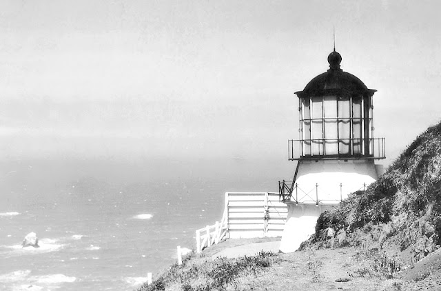
After poking around Shelter Cove, we drove back Shelter Cove Rd to Thorn Junction. There, we turned north toward Honeydew, picked up Mattole Rd, and at Lighthouse Rd turned west for Punta Gorda Lighthouse. Put into operation in 1912, the lighthouse was used by the Coast Guard during WWII. A lighted buoy eventually replaced the lighthouse, which was turned over to the BLM in 1951.

.jpeg)
Our 2003 route on the Lost Coast.
After poking around Shelter Cove, we drove back Shelter Cove Rd to Thorn Junction. There, we turned north toward Honeydew, picked up Mattole Rd, and at Lighthouse Rd turned west for Punta Gorda Lighthouse. Put into operation in 1912, the lighthouse was used by the Coast Guard during WWII. A lighted buoy eventually replaced the lighthouse, which was turned over to the BLM in 1951.

Doug recalls a photo of us at Punta Gorda, but unfortunately we’ve been unable to locate it.
Cape Mendocino Lighthouse, several miles to the north, predated Punta Gorda, starting operation in 1868. Both ships and lighthouse keepers faced treacherous conditions from frequent storms and earthquakes. The Coast Guard ran the lighthouse during WWII, after which it was automated. Later, a beacon was placed on a nearby cliff, where it operated until 2013. In 1998, the lighthouse was moved to Shelter Cove.

Cape Mendocino Lighthouse in original location.
Back on Mattole Rd, we drove north to Ferndale, a Victorian town reminiscent of Mendocino. Then it was back to 101 and continuing our trip north.

Ferndale, at northern end of Lost Coast.
A tad more on Hwy 1: We were headed home in November 2021, at the end of a 6-week meander. As we approached Leggett, Doug said, "101 or 1?" My quick response, "1!" and we were off on the 14 miles of two-lane-no-shoulders road that winds down along the edges of forested river canyons like a drunk cow. This is decidedly not one of Doug’s favorite drives, especially not on a dark and stormy night as we'd done previously.

This is what Hwy 1 from Leggett to the coast does for mile after mile. Strong stomach helpful.
But the Pacific Coast's glorious views are the reward for taking this route, and in 2021, we stopped in a turn-out to try to take it all in.

Nevertheless, after a few minutes of enjoying the views, Doug said he would never, ever do that road again. Period.


The reward for driving Hwy 1 from Leggett to the coast.
Nevertheless, after a few minutes of enjoying the views, Doug said he would never, ever do that road again. Period.

Hwy 1 concedes to the Lost Coast (our Promaster on the right).
Doug did, however, try to get to the Lost Coast again, in 2022. Driving home in the VW from Oregon, with a new transmission and an added limited slip (now both rear wheels would work together), he turned off 101 at Fernbridge. He found a dirt road that led to Shelter Cove, but recent rains and a sign warning against traveling it made him think otherwise. He returned to 101, promising himself to return soon.
The closest we've been to the Lost Coast otherwise is dinner at the Lost Coast Brewery in Eureka.
Boonville


Downtown Boonville.
Located in the Anderson Valley, Boonville began in 1862 as the Corners, then Kendall’s City. When a Mr. Boone bought a local hotel, he donated his name to the town.
In around the 1870s, a new language grew among the residents of the isolated farming and logging community. "Boontling" is said to be a combination of English, Scottish Gaelic, Irish, Spanish, Pomoan—the language of the Pomo Tribe, the original inhabitants of the area—and creativity. The websites of the Anderson Valley Museum, Anderson Valley Brewing Company, the Paris Review, and others recount the history of Boontling and contain Boontling glossaries. A few examples:
Boont: Boonville
harp: to speak Boontling
gorm: food, to eat
frattey: wine
jape: to drive a car
Poleeko: Philo, a town near Boonville
.jpeg)
Anderson Valley Brewing Company pale ale "Poleeko," Boontling for Philo, a nearby town.
There are a number of theories as to the origins of Boontling, all involving a desire for secret conversations: children wanting to prevent their parents from understanding what they were saying; women wanting to gossip in private while working the hop fields; men wanting to speak about topics such as sex—concerning which there are a rather large number of words in the dialect.

Hop pickers in burlap sacks to protect their clothing (photo, Anderson Valley Historical Society).
On the practical side, WWI soldiers were said to have used Boontling to get messages home past censors, and sports teams used it to confuse their opponents. Boontling was once taught in the local school. Some words have entered the popular culture, and Boontling language and history are preserved in print, but with Boonville’s current population at around 1,000, only about 12 of whom actively speak Boontling, the language is at risk of disappearing as an oral tradition.
.jpeg)
"Hobneelch'n"—Dance Party—Hoppy Saison Ale (photo, Josh Edelson, DailyMail.com).
Besides Boontling, Boonville is known today for wineries, the Mendocino County Fair and Apple Show, including sheep dog trials, the Sierra Nevada World Music Festival, and the Boonville Beer Festival.

Timbre corrals her sheep at Mendocino County Fair Sheep Dog Trials (photo, Anne Wernikoff, KQED).
Well, that’s enough hoopetedoodle for now. Bahl’ hornin’! Cheers!
* * * * *
A few Klamath River Basin sources
Andrews, Jessica Cejnar. "Klamath River Dam Removal Project Commences; KRRC Says Construction Crews Will Have Copco No. 2 Out In September." Wild Rivers Outpost, June 23, 2023. wildrivers.lostcoastoutpost.com/2023/jun/23/klamath-river-dam-removal-project-commences-krrc-s/
"Case Study: Klamath Basin." National Geographic. education.nationalgeographic.org/resource/case-study-klamath-basin/
Fisher, Konrad. "The Klamath River’s advocates succeed on their second try with new agreement for largest-ever dam removal." Waterkeeper. Water Alliance, Vol 13, Issue 1, Winter 2001. waterkeeper.org/magazines/volume-13-issue-1/klamath-river-dam-removal/
https://education.nationalgeographic.org/resource/case-study-klamath-basin/
Graber, Brian. “Five Key Lessons as World’s Biggest Dam Removal Project Will Soon Begin on the Klamath River.” American Rivers, Nov 17, 2022.
americanrivers.org/2022/11/five-key-lessons-as-worlds-biggest-dam-removal-project-will-soon-begin-on-the-klamath-river/#:~:text=PacifiCorp%20originally%20agreed%20in%20principle,River%20Renewal%20Corporation%20(KRRC).
Henshaw, Melanie. “Unnatural conflict in Klamath Basin: Conflicting interests in ongoing Klamath Basin water crisis forces difficult choices.” Street Roots, Feb 1, 2023. streetroots.org/news/2023/02/01/conflict-klamath-basin
"Klamath Basin." Wikipedia. en.wikipedia.org/wiki/Klamath_Basin
"Klamath Basin Dam Removal: 2001–2024." sustainablenorthwest.org/klamath-basin-dam-removal-history
"Klamath Basin National Wildlife Refuges." oregonwild.org/waters/klamath/refuges
"Klamath River." American Rivers. https://www.americanrivers.org/river/klamath-river/
"Klamath River Basin." Water Education Foundation. watereducation.org/aquapedia/klamath-river-basin
Most, Stephen. "Klamath Basin Project (1906)." oregonencyclopedia.org/articles/klamath_basin_project_1906_/
Peterson, Molly. "Removal of Klamath Dams Would Be Largest River Restoration in U.S. History." Oct 24, 2016.
kqed.org/news/11133820/removal-of-klamath-dams-would-be-largest-river-restoration-in-u-s-history
"Places We Protect: Lower Klamath Basin, California." The Nature Conservancy. nature.org/en-us/get-involved/how-to-help/places-we-protect/lower-klamath-basin/
"Reclaiming the Klamath." Earth Justice, Nov 23, 2020. earthjustice.org/feature/klamath-salmon-yurok-tribe
Ryner, Russ."Reuniting a River." National Geographic, Dec 2008. people.wou.edu/~taylors/g473/NGS_klamath_Dec_2008.pdf
"The Klamath River." oregonwild.org/waters/klamath/the-klamath-river
I always learn from your posts. Really enjoyed this one, which covered some places I've never been, and a few that I didn't know existed. Muchas gracias.
ReplyDeleteDenada! Y muchas gracias a tí tambien!
DeleteThank you again for the great reminders of the North State. I had a professor who considered himself the expert in Boonville and Bootling. A good section of an otherwise boring Etomology class.
ReplyDeleteI read about a professor at Chico State that I believe published a book on Boontling. Glad you enjoyed reading and thanks for commenting!
Delete