The Long and Winding Road from California to Washington, Part 9: Heading Home - Olympic Peninsula
November 1-4, 2021
After ten grand days with family and friends, it was time to head to our next destination, Port Townsend. First we took the Edmonds Ferry to Kingston, enjoying the chilly half hour crossing on deck. We love ferries and take them every chance we get, sometimes just for fun.
After ten grand days with family and friends, it was time to head to our next destination, Port Townsend. First we took the Edmonds Ferry to Kingston, enjoying the chilly half hour crossing on deck. We love ferries and take them every chance we get, sometimes just for fun.
Port Townsend, WA: Camped right on the harbor and bay—what could be better?
Yarn, fabric, and patterns from the many quilt and yarn shops Doug stopped at for Marilyn during our trip. He is always so patient and supportive of her creative endeavors.
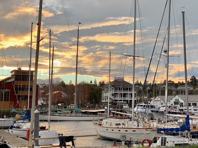
Port Townsend viewed from Hudson Point. Chandlery is on left.
Soon we arrived in Port Townsend. We headed directly to the Point Hudson Marina and RV park at the far end of town to check into our favorite campsite. It's dry site (no services) right on the water next to the dock, with unobstructed views of boat and ferry traffic. Most of the sites with hookups have views of their neighbors' RVs.
Our favorite Port Townsend campsite next to the harbor and Port Townsend Bay.
Port Townsend has an added significance to Doug. His father was in the Coast Guard during WWII and for two years was stationed at the Coast Guard base that is now the Point Hudson Marina.
It was cold and off-and-on rainy while we were in Port Townsend, apparently great weather for seagulls. One sat in a puddle next to our van, while others stood by the water in the wind, getting soaked by the waves. It made us cold just to look at them!
Doug getting shots of the ferry heading from Port Townsend to Coupeville, on Whidbey Island.
It was cold and off-and-on rainy while we were in Port Townsend, apparently great weather for seagulls. One sat in a puddle next to our van, while others stood by the water in the wind, getting soaked by the waves. It made us cold just to look at them!


We don't use our house heater much, as it is fueled by the gas tank, so after a rather cold first night, Doug checked with the office, and for a small additional fee, we were able to pull ahead to a site also on the water but with hookups. Now we could run our portable electric heater to our hearts' content.
Our new site, with hookups, still had an unobstructed view out the side.
We always enjoy exploring Port Townsend's downtown and uptown on foot. We masked to stop in a couple of stores but did not feel comfortable lingering.
Port Townsend
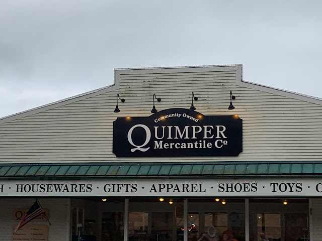
At the far end of town from the harbor is Quimper Mercantile Co. Marilyn has always wondered if there was a connection between it and Quimper, France, known for its pottery painted in primary colors and featuring folks in traditional Brittany garb. Marilyn has a couple of pieces of it.
Pottery of Quimper, France, not Quimper Peninsula, WA.
It turns out Port Townsend is on the Quimper Peninsula, and Quimper was a Peruvian-born French-Spaniard who helped chart the Strait of Juan de Fuca in the late–18th century.
Storm clouds at sunset from our site, November 1.
Sunrise, November 2.
Doug enjoys being around boats being hauled out.
Doug warm in his newly acquired watch cap just like his son's.
Our traditional Port Townsend vehicle pic, here by the ferry dock. Note, there are two ferries in the background, one arriving in Port Townsend and the other getting ready to cast off to the Coupeville Terminal on Whidbey Island.
Then it was time to truly begin the trek home...but we still had 12 days, so plenty of time to meander.
Heading west on the Olympic Peninsula.
Lake Crescent in the fog and rain.
As we drove beside the lake, there began to be a lack of traffic coming toward us, and we became suspicious of what that sign might have said. Soon we slowed to a stop behind a long line of traffic and next to another digital sign. This one clearly stated that the road would open again in two hours. Hmmm. What to do?
We decided to wait out the delay at Storm King Ranger Station, which we'd investigated en route. So we made a U-turn. Then the low tire light came on. What? We'd bought new tires in the spring and had them rotated and balanced before the trip. Doug pulled over and checked all the tires. The passenger rear was low. Feeling around the tire, we thought we heard a noise and felt air leaking.
Oh, boy! It is raining, and we have a flat tire!
Long story short, we parked at Storm King Ranger Station, Doug filled the tire with our emergency pump, and Marilyn called AAA. An hour later, the tire had not lost pressure, AAA was nowhere to be seen, and the rain continued. Another call to AAA. A young man arrived in another half hour. The tire was still holding pressure. After a conversation, it was agreed that it was probably feasible to drive to Sequim but stop and monitor the tire pressure on the way. If it went down, we would call him, and he would change the tire.
So off we went for the Discount Tire in Sequim, the same as Americas Tire in California, where we buy our tires. After a couple of stops to confirm the air pressure was still good, we arrived in Sequim.
It took the Discount Tire employee exactly about 90 seconds to find a small metal piece, about the size of a pen clip, embedded in the tire. Discount Tire provided their habitual amazing service, and within an hour the tire was patched. Meanwhile, Marilyn walked through the parking lot, up two flights of stairs, and down the sidewalk to the Grocery Outlet. She returned with six heavy bags, thereby getting her workout for the day.
All was good, but it was getting dark, and we needed a campsite. As we headed back through Port Angeles toward Lake Crescent, Marilyn found a campsite at Shadow Mountain RV Park, not spectacular, but a place to lay our heads.
Lake Crescent, heading back to Sequim.
Long story short, we parked at Storm King Ranger Station, Doug filled the tire with our emergency pump, and Marilyn called AAA. An hour later, the tire had not lost pressure, AAA was nowhere to be seen, and the rain continued. Another call to AAA. A young man arrived in another half hour. The tire was still holding pressure. After a conversation, it was agreed that it was probably feasible to drive to Sequim but stop and monitor the tire pressure on the way. If it went down, we would call him, and he would change the tire.
Lake Crescent, heading back to Sequim.
So off we went for the Discount Tire in Sequim, the same as Americas Tire in California, where we buy our tires. After a couple of stops to confirm the air pressure was still good, we arrived in Sequim.
It took the Discount Tire employee exactly about 90 seconds to find a small metal piece, about the size of a pen clip, embedded in the tire. Discount Tire provided their habitual amazing service, and within an hour the tire was patched. Meanwhile, Marilyn walked through the parking lot, up two flights of stairs, and down the sidewalk to the Grocery Outlet. She returned with six heavy bags, thereby getting her workout for the day.
All was good, but it was getting dark, and we needed a campsite. As we headed back through Port Angeles toward Lake Crescent, Marilyn found a campsite at Shadow Mountain RV Park, not spectacular, but a place to lay our heads.
Lake Crescent, back on track heading west.
The next morning we drove by Lake Crescent—no construction delays this time—and continued around the Olympic Peninsula. It was raining and foggy, which made it exciting when big logging trucks appeared out of the gloom barreling toward us.
Logging is a major industry and a way of life for many folks in California, Oregon, and Washington. Logging and lumber trucks, land that has just been logged, and plots of new trees are all frequent sights along the road. As logging companies work with a variety of lumber mills, we smiled when we saw lumber trucks heading in opposite directions.
Often rows of trees are left to somewhat shield from view an area that has been clear cut, but sometimes trees have been dropped right next to the road. We kept reminding ourselves that the harvesting of trees to provide wood for building homes and many other uses is another form of agriculture.
Fall colors, rain, and fog. Lake Crescent on the right.
Logs heading north to a lumber mill.
And more logs headed south to a lumber mill.
New growth in harvested plot with older trees behind.
Logs and sawn wood at saw mill.
Lumber headed to market.
Since it continued to rain, we continued to drive—as we meandered down the Pacific Coast, rain would be a constant. It would be nce if some of it could go further south to our area, but that is another story.
Rivers were flooding and mudslides were closing roads.
Each time we go through Raymond, there are more of the delightful two-dimensional metal figures of animals and people it is known for.
Raymond runs into South Bend, where we stopped at a favorite coffee shop, Elixir. With only a couple of other people and the staff wearing masks, we felt relatively safe relaxing inside for a while.
We also always stop at Elixir to check out Chauncey's Chair. Chauncey is the name our friend Tim acquired when he helped us on numerous occasions fixing up the house and yard of our house in Bellingham when we first bought it.
We continued down the coast to Ilwaco, then along the Columbia River. It looked grand but not where we'd want to be, with waves whipped up by the wind. Then it was across the Astoria Bridge, which climbs high over the river to allow ship traffic to pass, and into Astoria, OR.
We found our campsite at Fort Stevens State park, then returned to Astoria, another favorite place. The rain had stopped, for now, allowing a stroll around town.
Crossing the Chehalis River in Aberdeen.
Driving along the Willapa River in Raymond.
"But, Mo-o-om!"
Heron, deer, and raccoon enjoying Raymond's green space.
We might soon need a canoe, too.
Wallapa River from inside Elixir Coffee Shop.
Chauncey's Chair, Elixir Cafe, on Wallapa River, South Bend, WA.
We continued down the coast to Ilwaco, then along the Columbia River. It looked grand but not where we'd want to be, with waves whipped up by the wind. Then it was across the Astoria Bridge, which climbs high over the river to allow ship traffic to pass, and into Astoria, OR.
Driving along the Columbia River. Astoria Bridge near center of photo and Astoria, OR beyond.
We found our campsite at Fort Stevens State park, then returned to Astoria, another favorite place. The rain had stopped, for now, allowing a stroll around town.


Comments
Post a Comment
We love hearing from our readers! If you wish your comment not to be "Anonymous," you can sign into your Google account or simply leave your name at the end of your comment. Thanks!