The Long and Winding Road from California to Washington, Part 6: North through California
October 15-18, 2021
After ten days on the road enjoying Arizona, we were back in California making that right hand turn for Washington to spend time with Doug's children and a few friends. We now had six days to work our way to Seattle—plenty of time to meander and explore. For Doug this was rather comfortable, for his usual MO is to drive there in one day.

If we had driven I-5, the fastest route to Seattle, the drive would have been 1,159 miles and 18.5 hours. We actually didn't drive much further—1,295 miles—or longer—24.75 hours. But instead of divided highways and looking at vehicles for hours on end, we wandered up two-lane roads with great vistas in all directions.

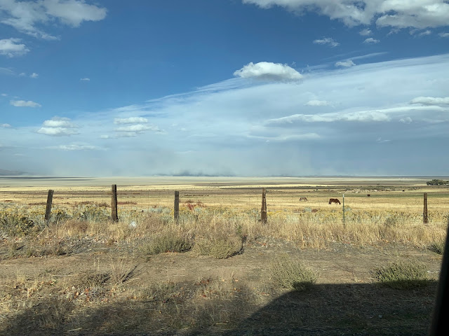
As we drove north on the east side of the Sierras through the Owens Valley we again savored the views of the valley, the Sierras to the west, and the White Mountains to the east. In the early-20th century, water rights in the area were sold to Los Angeles. Large pipes were built on the west side of Owens Valley to carry the water to LA. If you've ever driven over the "Grape Vine" on I-5 South, you've probably seen the huge pipes snaking over the hills. Almost a century later, LA agreed to stop diverting as much water, but what was once farmland remains vast open space, and dangerous dust rises from the alkali that covers much of the lake bed. Marc Reisner's excellent 1986 book Cadillac Desert documents the political wars over Los Angeles water, and in the 1974 film Chinatown, Jack Nicholson plays a private detective who in his investigation of of her matters uncovers corruption in a Los Angeles water project.


Our first night out of Barstow was to be the Alabama Hills. The area sits below Mt. Whitney with amazing views and rock formations. It's a place we love and have boondocked at numerous times, twice in the spring of this year. We reached the Alabama Hills about 3:00 PM, the perfect time to stop according to our 300 miles or 3:00 PM rule. Unfortunately, we didn’t check Campendium before going there, and, to our surprise, we found that camping is no longer allowed in our favorite area on the west side of Movie Rd.

BLM personnel at a pop-up site informed us this was due to folks loving the place to death. Rather than appreciating the beauty, too many people were loud and left their trash behind. Now camping is limited to a bit over 50 sites on the east side of Movie Road. It definitely is a loss to those of us who would have been willing to dedicate time to help clean up the area in order to keep it open.
We drove Movie Rd through the rest of the area but found no sites available. It was already 4:00 when we again consulted Campendium. The app once again led us to a great campground, Pleasant Valley, though it was another 70 miles to the north.

Once we figured which sites were available, we found ourselves camped on on the Owens River in a spacious and quiet spot. We'll definitely return.

The next morning, we headed back to Bishop to buy bread at Schatt's Bakery before continuing north to Mono Lake.

Once we arrived at the Mono Lake Visitors Center we found that it was already closed for the season. Fortunately the area had many informative signs, which we enjoyed.

Like Owens Lake, Mono Lake had its water diverted to Los Angeles for decades. The water level became so low that a land bridge formed from the lake's shores to Negit Island, which allowed coyotes easy access to the annual migrating bird populations. Several organizations were eventually successful in reducing the amount of water sent to LA and restoring the lake to a level that again allows for a safe stopover on the Pacific Flyway.

In addition to the water wars, Mono Lake is known for its tufa towers, white calcium deposits.


After an enjoyable visit it was off to South Lake Tahoe to visit Marilyn's sister and brother-in-law. Enroute we were saddened to see the burnt areas from the summer's Tamarack and Caldor Fires. Our visit with them in August had been cut short by the Caldor Fire, which eventually forced all of South Lake Tahoe to evacuate for a week. Our initial plan was to stay another day so Marilyn and her sister could spend more time together, but once again nature had a different plan. The weather reports were ominous, so we were back on the road north by noon the next day.

The wind was again blowing. Just south of Hallelujah Junction CA, there were warning signs.

Yes, our van is designated "high profile," but unlike the VW buses that Doug has driven for decades, it stayed in the lane.

Johnstonville is just south of our night's destination of Susanville, or 75 more miles of amazing wind. There were huge clouds of dust, in addition to the gray and puffy white clouds, moving across the sky.


Driving once again got a bit more exciting for awhile, and a few gusts definitely got Doug's attention, but that was it.


With the wind making it even colder, we decided against boondocking that night. We arrived in Susanville in time to buy a couple of items for the van, then checked into Days End RV Park, another Campendium find. It was everything the review said it would be, and for only $35: pleasant owners, neatly kept campground, electricity to run our electric heater and not use gas on the gas-powered one that lives under the passenger seat. Marilyn was pleased that not only was the bathroom impeccably clean and the showers plenty warm, but it also had everything a woman can want in a shower stall when camping and usually doesn't get: a seat, shelves, and multiple hooks. There was even a basket of soap, shampoos, and conditioners! And we could have done laundry if we'd needed to. An additional treat was the rooster at the neighboring farm that woke us in the morning—in time to enjoy the night's snow on the roads.

We didn't know where we were going except roughly north toward Bend, OR. Looking at the map we did the obvious: take the less-traveled route north to Alturas then east.
As we approached Tulelake, we saw signs for Lava Beds National Monument, and decided we'd drive through it. Despite AAA maps, GPS, and Google maps, we missed the turnoff and found ourselves in the town of Tulelake. Doug found the only gas station—a single pump outside a tiny market—by following his very capable nose.
Before going back to Lava Beds, we wanted to stop at the former site of the Tule Lake Internment Camp, now a national monument. It was 1 of 10 such places around the country in which Japanese-American citizens were forced to live during World War II, surrounded by barbed wire and guard towers. Tule Lake was the last to close, not until 7 months after the war ended.
 Entry gates and remaining building at Tule Lake Internment Camp.
The camp's buildings and land were then offered for free or little money to encourage people, including WWII veterans, to homestead in the area.

At Lava Beds National Monument Visitors Center, we learned that all but 3% of the monument had been burned over the last two years, 70% by the 2020 Caldwell Fire and another 27% by the 2021 Antelope Fire. Grasses and shrubs are beginning to return to the 2020 burn area, and hopefully areas burned in 2021 will begin to recover over the next year.

Medecine Lake Volcano, which has been erupting off and on for half a million years, created the lava beds. The monument's 73 square miles cover only about 10% of the 410-acre volcano, which forms a hill to the south of the monument.

Another bit of local history is the Modoc War. The Modoc Indians lived in this area for thousands of years. Beginning in 1826, with the determination of the US to claim more and more land, white settlers began to move into the area. The two groups lived cooperatively, but in 1850, California's first governor decided the Modoc should be exterminated. In 1864, the Modoc were forced to move to a reservation in Oregon.

In 1872, Captain Jack (Kintpuash) led half the Modoc tribe back to Tule Lake, where they hid in the caves of the lava beds, which were well-known to them. By wit and determination, a mere 58 warriors held off 1,000 soldiers for 8 months. General Canby was among those killed, which included only 6 Modoc. The US spent the equivalent of over $8 million in today's dollars on the Modoc War, at the end of which the Modoc were again deported from their land. Their descendants live in Oregon and Oklahoma.

In 1906, the Bureau of Reclamation began the Klamath Project to provide water for irrigation to develop farmland in Northern California and Southern Oregon. As part of the project, beginning in 1908, Tule Lake was periodically drained. Settlement was encouraged through a homesteader lottery for land. For eons, Tule Lake had been an "intermittent" lake, at times cut off by lava flows from Medecine Mountain Volcano, at times overflowing from precipitation, and at times so low it had no outflow. Since the Klamath Project began, there has been ongoing conflict between farmers and environmentalists. In 2021, the conflict over water rights heated up substantially.

Leaving the Visitors Center, we made our way to Lava Beds' Indian Well Campground, which was all but empty. We chose a spacious site on the outside of a loop with 360-degree views.


We are forever reorganizing the van, Marilyn the inside and Doug the garage, of the perfect system.
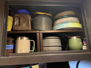

We so enjoyed our latest addition to the van, new drawers that run the full depth of the garage. These have simplified organization there and eliminated all the bins Doug used to have to sling around.

Ever the optimists, we'd brought our inflatable kayaks, but unfortunately they remained in their suitcases the entire trip.

At the Lava Beds we experienced one of the coldest nights of the trip, but despite the cold and the frosty campground, Marilyn was up and out early to make coffee. (Doug is pampered, often getting his coffee in bed, even when traveling.) On her trek to the restroom she greeted the workmen who were already busy constructing a new handicapped site.

We opted to enjoy our coffee inside the van with the heater on before getting on the road again.

With its caves and lava tubes, Lava Beds is popular with spelunkers. Doug couldn't resist checking out a couple of cave entrances before leaving and persuaded Marilyn to descend the ladders, also.


Numerous holes lead to caves, not all of them covered, so you have to be aware when walking on the ground above. We would like to return when we can actually explore further


We were glad to see new plants emerging from the landscape blackened by wildfires.


Leaving Tulelake, our van odometer reached 20,000 miles. Not bad for not quite two years since we bought it, including a year of pandemic, with little travel.

Now, where should we head as we continued north toward Washington, since we still weren't due for three days? Doug was comfortable, Yet, he thought, less planning means more flexibility...
After ten days on the road enjoying Arizona, we were back in California making that right hand turn for Washington to spend time with Doug's children and a few friends. We now had six days to work our way to Seattle—plenty of time to meander and explore. For Doug this was rather comfortable, for his usual MO is to drive there in one day.
California: Day 1: East Side of Sierras. Day 2: South Lake Tahoe. Day 3: A Blustery Drive to Susanville. Day 4: Tulelake.
If we had driven I-5, the fastest route to Seattle, the drive would have been 1,159 miles and 18.5 hours. We actually didn't drive much further—1,295 miles—or longer—24.75 hours. But instead of divided highways and looking at vehicles for hours on end, we wandered up two-lane roads with great vistas in all directions.
Driving north on the east side of the Sierras.
Owens Lake with the White Mountains to the east.
Alkali covers much of Owens Lake bed. We recently read that there has been an attempt to reduce the hazardous dust by coating parts of the lake.
Our first night out of Barstow was to be the Alabama Hills. The area sits below Mt. Whitney with amazing views and rock formations. It's a place we love and have boondocked at numerous times, twice in the spring of this year. We reached the Alabama Hills about 3:00 PM, the perfect time to stop according to our 300 miles or 3:00 PM rule. Unfortunately, we didn’t check Campendium before going there, and, to our surprise, we found that camping is no longer allowed in our favorite area on the west side of Movie Rd.
Alabama Hills: Mobius Arch with Mt Whitney beyond.
BLM personnel at a pop-up site informed us this was due to folks loving the place to death. Rather than appreciating the beauty, too many people were loud and left their trash behind. Now camping is limited to a bit over 50 sites on the east side of Movie Road. It definitely is a loss to those of us who would have been willing to dedicate time to help clean up the area in order to keep it open.
We drove Movie Rd through the rest of the area but found no sites available. It was already 4:00 when we again consulted Campendium. The app once again led us to a great campground, Pleasant Valley, though it was another 70 miles to the north.
Pleasant Valley Campground on Owens River north of Bishop.
The next morning, we headed back to Bishop to buy bread at Schatt's Bakery before continuing north to Mono Lake.
East side of the Sierras north of Bishop.
Mono Lake has two main islands: Negit, on the left, and Paoha, the larger, on the right.
Mono Lake tufa towers.
Rubber rabbitbrush (yellow flowers) and big sagebrush on shores of Mono Lake.
9- X 13-mile Mono Lake was beautiful under seering blue skies.
We were on 395, which from Tahoe dips into Nevada before returning the California.
Um...that would be us...
Yes, our van is designated "high profile," but unlike the VW buses that Doug has driven for decades, it stayed in the lane.
Only 75 miles to go...
Clouds of dust blew across the landscape,...
...across barren fields,...
...and across the road.
Except for the dust, it was a beautiful drive past fields of alfalfa...
...headed for happy California cows that were hunkered down amid the dust storm.
Snow heading north out of Susanville.
As we approached Tulelake, we saw signs for Lava Beds National Monument, and decided we'd drive through it. Despite AAA maps, GPS, and Google maps, we missed the turnoff and found ourselves in the town of Tulelake. Doug found the only gas station—a single pump outside a tiny market—by following his very capable nose.
Before going back to Lava Beds, we wanted to stop at the former site of the Tule Lake Internment Camp, now a national monument. It was 1 of 10 such places around the country in which Japanese-American citizens were forced to live during World War II, surrounded by barbed wire and guard towers. Tule Lake was the last to close, not until 7 months after the war ended.
Entry gates and remaining building at Tule Lake Internment Camp.Marker at Tule Lake Internment Camp.
97% of Lava Beds burned in 2020 and 2021 wildfires. Juniper— the blackened trees—will hopefully come back.
Medecine Lake Volcano underlies the lava beds and forms a hill to the south (we're not sure if this is the volcano or one of many cinder cones).
Modoc dugout canoe of Jennie Clinton, the last survivor of the Modoc War.
The Modoc also made canoes of bundled tule stalks. (Photo from Lava Beds Visitor Center.)
In 1906, the Bureau of Reclamation began the Klamath Project to provide water for irrigation to develop farmland in Northern California and Southern Oregon. As part of the project, beginning in 1908, Tule Lake was periodically drained. Settlement was encouraged through a homesteader lottery for land. For eons, Tule Lake had been an "intermittent" lake, at times cut off by lava flows from Medecine Mountain Volcano, at times overflowing from precipitation, and at times so low it had no outflow. Since the Klamath Project began, there has been ongoing conflict between farmers and environmentalists. In 2021, the conflict over water rights heated up substantially.
Doug at our Indian Well Campground site.
Leaving the Visitors Center, we made our way to Lava Beds' Indian Well Campground, which was all but empty. We chose a spacious site on the outside of a loop with 360-degree views.
Indian Well Campground, Lava Beds National Monument: camped amid burnt trees.
Marilyn thought the picnic tables made of wood and lava rocks were some of the most artistic she'd seen.
We were in a burn area from the recent wildfires, yet there were signs of life.
In addition to lava, there are many cinder cones like the one in the background.
Marilyn's latest reorganization of the overhead kitchen cabinets.
Drawers have made garage organization infinitely better. Removable table on right side is for cooking on our 2-burner camp stove. Marilyn made the pocket organizers on the doors.
Ever the optimists, we'd brought our inflatable kayaks, but unfortunately they remained in their suitcases the entire trip.
Inflatable kayaks are in the 2 gray suitcases.
At the Lava Beds we experienced one of the coldest nights of the trip, but despite the cold and the frosty campground, Marilyn was up and out early to make coffee. (Doug is pampered, often getting his coffee in bed, even when traveling.) On her trek to the restroom she greeted the workmen who were already busy constructing a new handicapped site.
Marilyn braved the frost to get coffee going on the JetBoil outside.
We opted to enjoy our coffee inside the van with the heater on before getting on the road again.
Icey windshield. Yes, it was cold!
Ladder into cave--we didn't go beyond the entrance.
Marilyn courageously entered a cave.
When bats are in residence, caves are closed.
Marilyn walks cautiously around a cave, wary of hidden holes.
Hole dropping into cave partially hidden by brush.
We were glad to see new plants emerging from the landscape blackened by wildfires.
Sagebrush reemerging after the wildfires.
Bunchgrass & rabbitbrush.
Rabbitbrush buds.
We reached 20,000 miles of travel in the van in less than 2 years.
Note: For those, who, like Marilyn, are linguistically and grammatically inclined, the spelling is Tulelake for the town and Tule Lake for the internment camp, the lake, and the national wildlife refuge.
Great sounding trip. I’ve always wanted to make the trip. Remember the clothes you wore into the cave. The bat disease White Nose Syndrome hides in clothing. Supposedly it’s been found in caves near Mt. Shasta.
ReplyDeleteLooking forward to seeing more stories.
Great sounding trip. I’ve always wanted to make the trip. Remember the clothes you wore into the cave. The bat disease White Nose Syndrome hides in clothing. Supposedly it’s been found in caves near Mt. Shasta.
ReplyDeleteLooking forward to seeing more stories.