The Long and Winding Road from California to Washington, Part 1
October 5-7, 2021

Our dining room table is frequently covered with maps.
Discussions ensued: should we go up the Pacific Coast? east to the Southwest then north? inland through California, Oregon, and Washington?
No matter the route, we planned to spend the first night in the Alabama Hills on the east side of the Sierras (we live on the west side).
As the map below shows, we soon realized that visiting the Alabama Hills was a bit of a detour. Despite our meandering tendencies, it just didn't make sense to go there for the third time this year and then have to drive all the next day to get to Valley of Fire. So the night before departure, we crossed Alabama Hills off the route.

We were ready to go. All that was left was one last check of the house, until the door knob came off in Marilyn's hand when she opened the front door. This was not a duct tape job. But an hour later, we'd fixed the door knob and finally pulled out of the driveway.
Several hours later, driving past Las Vegas on the interstate, we commented again that we should spend a couple days there just being tourists, but not this time. We headed north on I-15 to Valley of Fire West Dispersed Camping, arriving in time for the first of many gorgeous sunsets during our trip.
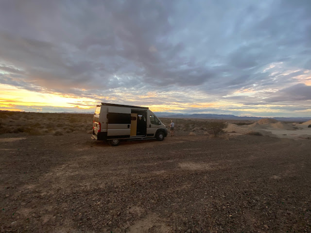
Valley of Fire West Dispersed Camping, 55 miles northeast of Las Vegas.
The next morning, we were at Arch Rock Campground in Valley of Fire State Park by 9:00. We chose the "perfect spot," an isolated site nestled between amazing rocks.
A couple of hours after we settled in, the wind changed direction, and our perfect site was no longer, as predictable odors wafted over from the outhouse. Oops, but the campround was full.

Our 1st Valley of Fire campsite, behind the outhouse.

Though Valley of Fire is small and compact, we found it to be as beautiful and astounding as many larger parks we have visited.
Returning to our site we found that the wind did change often, but we needed a new site. That was resolved early the next morning, when we moved into another site as soon as its occupants pulled out. We then enjoyed not only the beauty but the fresh air.

2nd campsite, far from the outhouse.

A few of the numerous petroglyphs on Mouse's Tank Trail.
Then we were off to hike #2, the Fire Wave, a 1.5-mile-roundtrip hike across the red sandstone, with a final steep descent to the wave.

Doug, beginning of Fire Wave Trail, before the steep descent.

Looking down to the Fire Wave.

The colors and patterns all around are mind boggling.

Marilyn at the top of the wave.

Doug hiking up from the wave.

Marilyn loves the jade hues of some of the rock.
Our third trail was White Domes. Marilyn was going to pass, but Doug asked, “How hard could a 1.25-mile loop be?” The trail began with deep sand, nothing new by this point. As it sloped down, we began to pass people returning.

Marilyn at top of White Domes canyon. People below appear quite small.

Looking back to the top. It was not a piece of cake getting down but definitely worth it.

Doug navigating sideways down a ridge near the bottom of the canyon.


The trail then passes through a slot canyon.

When it was pouring rain the next day, we were glad not to be in the slot canyon.
A gentleman we met along the trail (picture below) said it rather well, "Everything you want to see in the desert is here."


The rock colors and patterns seem infinite.


After our siesta, it was time for showers, dinner, and contemplating the next leg. Marilyn had been saying for weeks she wanted to go to the North Rim of the Grand Canyon again. But with colder weather approaching, she asked what we'd do there After a quick discussion, we decided to head instead for the South Rim, which is 1,000 feet lower.
So early the next morning we were off, but first, a side trip to check out Hoover Dam.

After an intense security check, including inspecting the inside of the van, we were able to drive across Hoover Dam, crossing from Nevada to Arizona, and park.

Lake Mead is well below capacity, as indicated by the white bathtub ring.
Though we had read about how low the "lakes" (reservoirs) on the Colorado River are, we were still shocked to see the white bathtub ring (high water mark) of Lake Mead extend far above the current level of the lake.

Bronze statue of a high scaler, men who, during dam construction, rappelled down the canyon walls with jackhammers and dynamite to blast away the walls to make room for the dam.
Looking at the surrounding geography, it is difficult to imagine building a dam in that location. It was sobering to read that almost 100 lives were lost in the process.
Our visit to the dam provided a lot of food for thought, but it was now time to head off to the South Rim of the Grand Canyon. The drive was enjoyable, especially as we encountered rain the majority of that leg, a unique experience for us as we live where rain is rare.
Lovin' it.
ReplyDeleteThanks!
DeleteWhat great places you've been. I haven't heard of half of the sites you mentioned. Someday...
ReplyDeleteWe have been to some amazing places & discovering new ones is always grand.
DeleteSeems you two are having a great trip! Keep the pictures and stories coming…
ReplyDeleteDan & Sally
Thank you😎
Delete(Hmm) just sent a comment but not showing. Didn’t go thru? You have to approve it? Will see what happens…
ReplyDeleteI used to have to approve, but quit doing that. I also don't know if folks receive notice that I've responded to their comments. Maybe you could let me know if you are notified of this response to your two-year-old comment? (Why didn't I respond before???)
Delete