Southwest 2021-14: Mule Canyon Ruins and Natural Bridges National Monument
March 21-22, 2021
After four amazing days in Moab, we enjoyed a last visit with our friends, for now, then headed south. Our vague destination had been Mexican Hat, with the idea of camping at Goosenecks State Park. The next day, we'd drive up the Moki Dugway, a favorite road of Doug's. However, after going through Monticello and Blanding we saw the sign for Natural Bridges and on an impulse turned west on 95.
Driving 95 reminded us of going across Nevada 50: a succession of basins and ridges. About 15 miles from the turnoff, we climbed over Comb Ridge. It's a 120-mile-long monocline—layers of horizontal rock that all slope downward—running north south. That's a very rough definition. For a more thorough treatment here's a link to the geology of Capitol Reef National Park, including the Water Fold, which is also a monocline.On the west side of "the Comb" is Comb Wash.
Debating whether to get a sure campsite or risk Natural Bridges, which has only 13 first come-first served sites, we drove through Comb Wash BLM Campground. We investigated several sites, then decided to check out the camping on the other side of the highway before making a final decision. We passed only three sites before coming to a small sign that said if we continued we'd be trespassing on reservation land. We decided just to go on. Soon we came upon the Mule Canyon Ruins just off the road.
Anasazi lived in this area from about 750-1150. In the Comb are ruins of cliff dwellings and granaries and many petroglyphs. Excavation at Mule Canyon revealed an L-shaped block of 12 rooms, a pithouse, 2 kivas, a tower, and a trash area.
It's thought that 2 or 3 families occupied the rooms. A tunnel connected the room block to the kiva, while on the other side of the kiva, another tunnel connected it to the tower.
In direct line of site from the tower to the southeast are the Cave Towers, so perhaps the towers served for communication. Given the tunnel from the kiva to the tower, another possibility is that the towers use was defense or ceremonial. Tunnels are not common in this area, which, along with pottery shards found at the site, indicates an influence by the Anasazi of Mesa Verde in Colorado.
We left the ruins and continued on to Natural Bridges. To our joy we had our choice of sites! We settled into a large site with a view out over the valley. Within three hours, the campground was full.

From a nearby juniper tree, a Juniper Titmouse, was quite brazen. The couple times a morsel dropped from Doug's hand as he read, the bird zoomed from the tree and snatched it up almost before it hit the ground.
Natural Bridges sits in a juniper and pinyon forest, common at elevations from 4,500 to 7,500 feet that experience temperature extremes and have little water.
We had seen junipers loaded with berries earlier in our trip in Joshua Tree National Park, much of which is at 5,500 feet in elevation. When water is scarce, a juniper will actually stop water from going to its major branches.
After four amazing days in Moab, we enjoyed a last visit with our friends, for now, then headed south. Our vague destination had been Mexican Hat, with the idea of camping at Goosenecks State Park. The next day, we'd drive up the Moki Dugway, a favorite road of Doug's. However, after going through Monticello and Blanding we saw the sign for Natural Bridges and on an impulse turned west on 95.
Driving 95 reminded us of going across Nevada 50: a succession of basins and ridges. About 15 miles from the turnoff, we climbed over Comb Ridge. It's a 120-mile-long monocline—layers of horizontal rock that all slope downward—running north south. That's a very rough definition. For a more thorough treatment here's a link to the geology of Capitol Reef National Park, including the Water Fold, which is also a monocline.On the west side of "the Comb" is Comb Wash.
This satellite map is especially good for showing Comb Ridge, running north and south, and on its western edge, Comb Wash.
Debating whether to get a sure campsite or risk Natural Bridges, which has only 13 first come-first served sites, we drove through Comb Wash BLM Campground. We investigated several sites, then decided to check out the camping on the other side of the highway before making a final decision. We passed only three sites before coming to a small sign that said if we continued we'd be trespassing on reservation land. We decided just to go on. Soon we came upon the Mule Canyon Ruins just off the road.
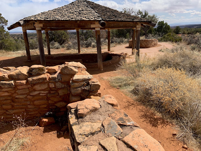
Mule Canyon Anasazi ruins: looking from housing block to kiva (under protective roof) and tower.
Anasazi lived in this area from about 750-1150. In the Comb are ruins of cliff dwellings and granaries and many petroglyphs. Excavation at Mule Canyon revealed an L-shaped block of 12 rooms, a pithouse, 2 kivas, a tower, and a trash area.
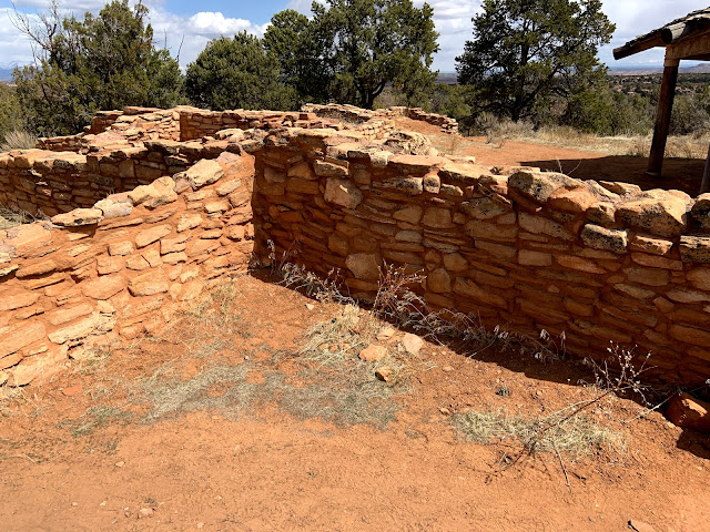
L-shaped block of rooms.
Kivas were typically used for ceremonies and meetings. The opening in the wall is a tunnel to block of rooms.
It's thought that 2 or 3 families occupied the rooms. A tunnel connected the room block to the kiva, while on the other side of the kiva, another tunnel connected it to the tower.
Kiva and Tower, believed to have been 2 stories tall, beyond. Opening in wall is tunnel to tower. Vertical slab deflected heat from fire built opposite it
In direct line of site from the tower to the southeast are the Cave Towers, so perhaps the towers served for communication. Given the tunnel from the kiva to the tower, another possibility is that the towers use was defense or ceremonial. Tunnels are not common in this area, which, along with pottery shards found at the site, indicates an influence by the Anasazi of Mesa Verde in Colorado.
Arriving at Natural Bridges National Monument
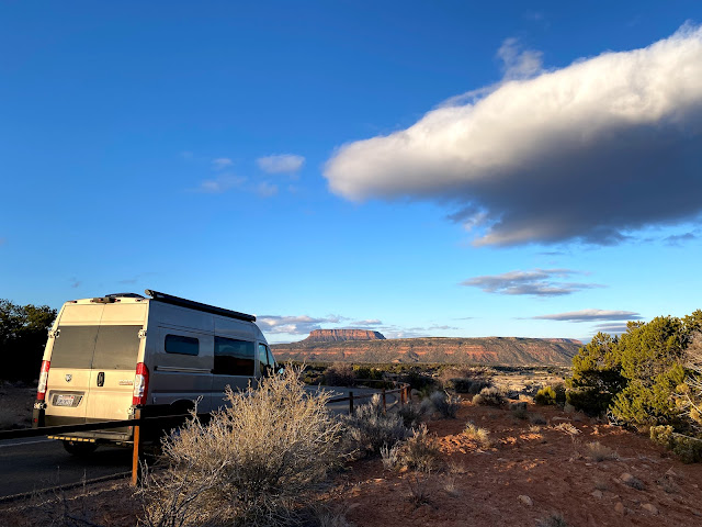
We left the ruins and continued on to Natural Bridges. To our joy we had our choice of sites! We settled into a large site with a view out over the valley. Within three hours, the campground was full.

View from our Natural Bridges campsite.
It was chilly enough for down jackets, but the sun was warm.
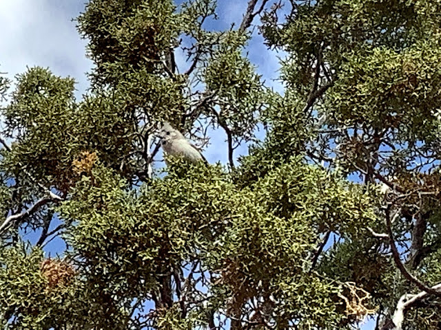
Juniper Titmouse, a small cute, but pesky, little guy, in Juniper tree
From a nearby juniper tree, a Juniper Titmouse, was quite brazen. The couple times a morsel dropped from Doug's hand as he read, the bird zoomed from the tree and snatched it up almost before it hit the ground.
Juniper tree, right, and pinyon pine, left
Natural Bridges sits in a juniper and pinyon forest, common at elevations from 4,500 to 7,500 feet that experience temperature extremes and have little water.
Berries on Juniper tree
We had seen junipers loaded with berries earlier in our trip in Joshua Tree National Park, much of which is at 5,500 feet in elevation. When water is scarce, a juniper will actually stop water from going to its major branches.
Pine cones on pinyon pine
Pinyon pines, from which we get piñons, or pine nuts, grow at most to 20 feet tall. A tree that is only 6 inches in diameter and 10 feet tall might be 80 years old.

We left before coffee the next morning to enjoy the views of the major natural bridges. First up was Sipapu Bridge. It's a little hard to spot from a distance.
Though there may not be water under the bridges now, bridges are formed by moving water eroding rock. By contrast, arches, such as those in Arches National Park, which we'd visited earlier in our trip, often form when water seeps through cracks in rocks and freezes. Water and wind continue to enlarge the cracks until all that's left of the rock is an arch.
Leaving Natural Bridges, we saw to the north the two buttes that make up the Bears Ears the national monument is named for. Bears Ears has often been in the news in recent years. Barack Obama designated it a national monument in 2016. In 2017, his successor diminished it by 85%. "What Remains of Bears Ears," an April 2019 article in the Washington Post, is an excellent analysis of the history and issues of Bears Ears, with maps and fabulous pictures and drone footage of cliff dwellings and petroglyphs. Joe Biden is reviewing some of his predecessor's changes to national lands, and his Interior Secretary, Deb Haaland, herself a Native American, toured Bears Ears in April 2021.The Bears Ears Inter-Tribal Coalition has long been working to protect the ancestral lands of numerous Indian tribes.
Next up: Muley Point; Doug's favorite, the Moki Dugway; and camping on the edge of the Goosenecks of the San Juan River.

Uncle Robert, aka Conchita, at a pull out at Natural Bridges National Monument
We left before coffee the next morning to enjoy the views of the major natural bridges. First up was Sipapu Bridge. It's a little hard to spot from a distance.
Arrow points to Sipapu Bridge
Zoomed in to Sipapu Bridge.
Though there may not be water under the bridges now, bridges are formed by moving water eroding rock. By contrast, arches, such as those in Arches National Park, which we'd visited earlier in our trip, often form when water seeps through cracks in rocks and freezes. Water and wind continue to enlarge the cracks until all that's left of the rock is an arch.
The next bridge, Kachina, was a little easier to spot.
It's amazing how water carved its course through the rock.
Here a tunnel goes under the rocks, perhaps making, in a few centuries, a new bridge.
Bears Ears
Leaving Natural Bridges, we saw to the north the two buttes that make up the Bears Ears the national monument is named for. Bears Ears has often been in the news in recent years. Barack Obama designated it a national monument in 2016. In 2017, his successor diminished it by 85%. "What Remains of Bears Ears," an April 2019 article in the Washington Post, is an excellent analysis of the history and issues of Bears Ears, with maps and fabulous pictures and drone footage of cliff dwellings and petroglyphs. Joe Biden is reviewing some of his predecessor's changes to national lands, and his Interior Secretary, Deb Haaland, herself a Native American, toured Bears Ears in April 2021.The Bears Ears Inter-Tribal Coalition has long been working to protect the ancestral lands of numerous Indian tribes.
Next up: Muley Point; Doug's favorite, the Moki Dugway; and camping on the edge of the Goosenecks of the San Juan River.


Comments
Post a Comment
We love hearing from our readers! If you wish your comment not to be "Anonymous," you can sign into your Google account or simply leave your name at the end of your comment. Thanks!