Death Valley and Beyond - March 2012
Weather can reroute an entire trip—sometimes for the best! On our winter trip to Death Valley, winds diverted us south to happily discover new places.

When our home in California's San Joaquin Valley is foggy and damp with winter, we love to escape to the desert's warmth in winter. So in late February, we headed out in our VW Vanagon, destination Death Valley National Park. On the tentative agenda: a hike to Zabriskie Point; a drive through one-way Titus Canyon; visits to Rhyolite ghost town, Ubehebe Crater, and the Racetrack; and a visit to Amargosa Opera House in Death Valley Junction.

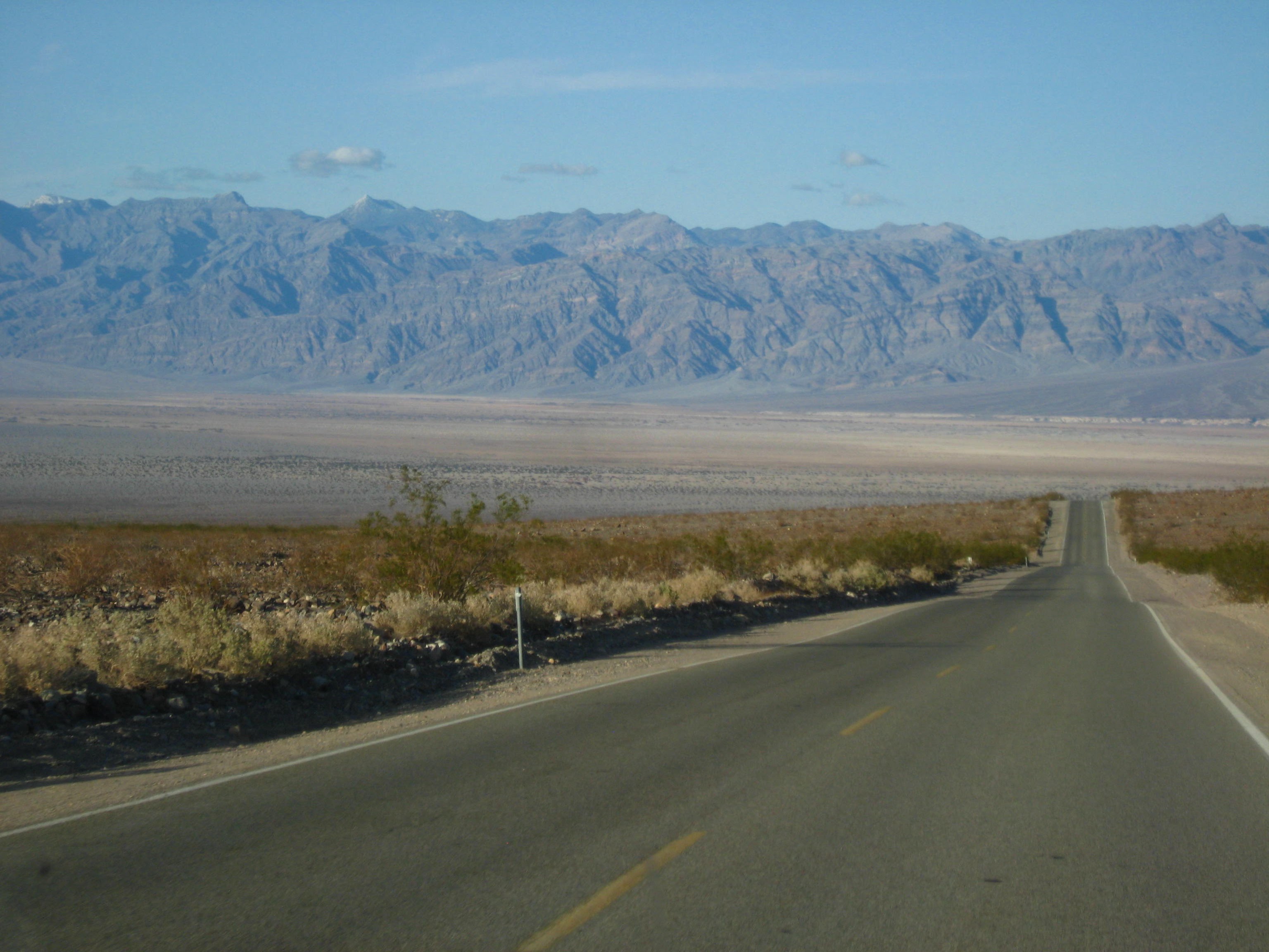
Death Valley is about due east of Visalia, but you have to drive south to Bakersfield, east through the Tehachapi Pass, and back north to get there, about 280 miles. There was snow as low as Tehachapi, around 4,000 feet.

We were in Stovepipe Wells in 4 hours, headed for Texas Springs Campground in the hills across from Furnace Creek. It's our favorite because there are no hookups and no generators are allowed


Unfortunately, when we arrived at Texas Springs a half hour later, we discovered it was temporarily designated for tents only, due to renovations at Furnace Creek Campground. With a VW van, we can often stay in tent sites, but the Texas Springs policy was strict. We drove back down to Sunset, a massive asphalt campground, and found a spot away from most RVs and their generators. Sunset doesn't have hookups either. 
A sign high on the cliffs across the road marks sea level.


The cement viewing area and the boardwalk out into the valley are crusted with salt deposits that build up and break down each year with the flash floods that can rage through the valley.


.heic)
We continued south and were out of Death Valley about 50 miles beyond Badwater. Soon we arrived at Shoshone Village. It's situated within the Shoshone Wetlands Preserve, which contains several birding trails.
We spent a few minutes in the small museum looking at pictures and stories of pioneer women of Amargosa Valley and old farm and mining equipment. Outside was a nice display of area rocks, with explanations of each geologic era they represent.
We decided to continue south about 7 miles to investigate China Ranch Date Farm. The pavement of China Ranch Road turned to dirt and began a steep curving descent that cut through an alluvial fan.

The sides of the alluvial fan rose high above us, looking like a lunar landscape. We passed a number of old mine shafts.

We imagined we'd see half a dozen date palms at the end of the road and not much more. Boy were we wrong!

What greeted us instead were groves of lush date palms! The small family date farm is the latest incarnation of an area that has produced various crops and livestock since the latter half of the 19th century. It was also a mining area, mainly for talc, lead, silver, and gypsum.

As we learned in A Modest Museum, it seems a certain Ah Foo farmed the area in the latter half of the 19th century, then disappeared around 1900. The land passed through various hands until its 1920s owner, having never seen a date, let alone a date palm, ordered date seeds and, when they arrived, planted them.

Those seeds grew into the towering date palms that continue today to line the drive to the handsome adobe house. One of the current owners is, serendipitously, Hawaiian of Chinese descent. They reinvigorated the date orchard in the 1990s and now grow nearly a dozen varieties of California and Middle Eastern origin.

The small store sells date products, local art, and collectibles. We sampled the dates, and I had to have a date shake—it was as delicious as the one I had forty years ago in Indio, CA.
China Ranch is an oasis. It was a watering spot on the Old Spanish Trail, which ran from Santa Fe to Los Angeles, and was a stopping place for the likes of John Fremont and Brigham Young. According to the sign on the side of the store, Kit Carson actually slept there.

The Amargosa River Trail begins behind the store, and we thought we'd walk down it a short way. We ended up spending over two hours exploring the area. The Amargosa (Spanish for "bitter") River begins in northeast Nevada, runs southwest underground, and emerges at Shoshone. From there it runs west some miles then dives underground again, ending back north in Badwater. In this area, it flows through the Amargosa Canyon and is under the control of the BLM.

The trail is marked by cairns, some of which have become quite elaborate with the additions of passing hikers.

After about a mile, we came to the confluence of Willow Creek and the Amargosa River.


Despite the oasis at our back and the greenery along the creek, it's typical Mojave Desert here: sand on the flats and hills and mountains that vary in composition from black volcanic rock and cinder cones to upheaved layers of rock in various shades of brown.

Leaving the stream behind, we followed the trail toward a sizable hill of mine tailings.

In mining days, this area was called Morrison.

The remains of the Tonopah and Tidewater Railroad bed run alongside the tailings at the foot of the mound. We surmised that the extracted minerals were pushed over the side of the mound through wooden chutes into waiting rail cars.

We climbed the railroad embankment and walked along the ties.

The BLM, with the support of the Rails-to-Trails Conservancy, is converting the railroad bed to a 17-mile trail.

As the trail turned back toward China Ranch, it was marked with typical brown metal stakes.

Brown, green, and blue bits of glass glinted in the sun on a slope where the trail curved down to the remains of the assay office.

 Assay office.

We thought the assay office might later have been a saloon. The remains of a nearby box spring seemed to support this conjecture, since saloons typically provided the services of ladies of the night.

Nearby was a dump containing an assortment of old metal cans, boxes, car parts, box springs, and a few pieces of broken pottery.

Particularly eerie were the crib-size box springs, one with a mesquite bush pushing thick pointed branches up through it.

We left China Ranch more than content with our discovery and in a few minutes were in Tecopa.

The desert sky that night was black, with the moon, Jupiter, and Venus standing out among the mass of stars. We were snug in our sleeping bag when the winds came up again during the night, with the tree providing a buffer.

In the morning we continued north a half hour to Death Valley Junction and the Amargosa Hotel and Opera House.

Built in 1923 as the civic center of the Pacific Coast Borax Company, the buildings included company offices, a store, an employee dorm, a hotel, a dining room, a gym, a billiard room, an ice cream parlor, and a community center. Remember the 20 Mule Team Borax commercials?
Standing among the remains of Rhyolite, one can almost hear the hustle and bustle of the 8,000 people who once lived here.
Down the hill from town, rows of mostly unmarked mounds populate the cemetery. One stands out, fenced in and fancifully ornamented: the gravesite of one Isabel Haskins, aka Mona Belle, former inhabitant of the red light district. According to legend, the grave did not exist until 20 years after Mona Belle's tragic death.

We spent our last night at Emigrant, a 10-site free campground a few miles west of Stovepipe Wells. We slid into sleep looking through the Vanagon's back window at the moon and planets, the Big Dipper, Cassiopeia, Orion the Hunter, the Pleiades, and the countless other stars and constellations in the vast darkness and quiet of our last desert night.
When we reached 395 the final morning of our trip, we decided to head north to visit Manzanar, 1 of 10 "relocation" centers to which tens of thousands of Japanese Americans, the majority of them American citizens, were moved within months of the bombing of Pearl Harbor. It was designated Manzanar National Historic Site in 1992.
.heic)
The former high school gymnasium serves as headquarters and information center. Over 11,000 people were interned here for all or part of the center's existence, which ended a few months after Japan's surrender in 1945.

We visited the information center then walked through replicas of barracks and a mess hall. Recorded sounds gave the sense of ghosts of those who endured the camp. Eight-by-ten-foot gray mesh screens with photographs of people cooking and eating hung among the long tables and benches, creating an atmosphere of confinement and lack of privacy. Every aspect of life here was communal. People made their crowded barracks quarters as comfortable as possible and turned the desert colorful with crops and gardens. Reconstruction of the camp's buildings has been ongoing. We came across concrete-lined ponds and bridges, the remains of garden parks the residents created. A design in pebbles gives the date one garden was constructed.
The cemetery remains outside the grounds. A snow-white obelisk, with the snow-capped Sierras beyond, is lettered in Japanese characters in black meaning "soul consoling tower." The cemetery and displays at Manzanar rightfully demand that we remember this event and contemplate its meaning for our nation.
We made one more stop, in Lone Pine. There we looked up at the east side of the Sierras and Mt Whitney before continuing our drive to home on the Sierras' west side. We'd been to the lowest point in the continental US at Badwater and now looked at its highest point, Mt Whitney, and in between those bookends we'd experienced the fascination and contemplation of geology and history.

Death Valley's colors.
When our home in California's San Joaquin Valley is foggy and damp with winter, we love to escape to the desert's warmth in winter. So in late February, we headed out in our VW Vanagon, destination Death Valley National Park. On the tentative agenda: a hike to Zabriskie Point; a drive through one-way Titus Canyon; visits to Rhyolite ghost town, Ubehebe Crater, and the Racetrack; and a visit to Amargosa Opera House in Death Valley Junction.

Winter outing to Death Valley & beyond.
Death Valley is about due east of Visalia, but you have to drive south to Bakersfield, east through the Tehachapi Pass, and back north to get there, about 280 miles. There was snow as low as Tehachapi, around 4,000 feet.

Heading to Death Valley—windmills on the hills of Tehachapi Pass.
We were in Stovepipe Wells in 4 hours, headed for Texas Springs Campground in the hills across from Furnace Creek. It's our favorite because there are no hookups and no generators are allowed
Hwy 190 leaving Stovepipe Wells.

Mesquite Flat Sand Dunes.
As predicted, morning brought high winds, so rather than do the exploring and hiking we'd planned, we made our way south. First stop was Devil's Golf Course, a 1/4-mile drive out into the valley on a washboard road. The landscape looks like a massive batch of oatmeal cookie dough plopped on a cookie sheet and frosted before baking.

Walking on Devil's Golf Course barefoot or in flipflops is definitely not recommended as the merest brush with the salt crystals could mean a nasty cut—with salt added to the wound right then and there.
 Close-up of Devil's Golf Course, so named for its jagged surface that "only the devil could golf on."

The desert wasn't blooming, but it had hues of green and a fair amount of water in what thousands of years ago was 600-foot-deep Lake Manly. On the way into the valley we'd even seen people wading in the lake.

Next stop was Badwater, the lowest point in the continental United States, at 282 feet below sea level.
Devil's Golf Course.
VW at Devil's Golf Course.
Walking on Devil's Golf Course barefoot or in flipflops is definitely not recommended as the merest brush with the salt crystals could mean a nasty cut—with salt added to the wound right then and there.
Close-up of Devil's Golf Course, so named for its jagged surface that "only the devil could golf on."
Devil's Golf Course. Telescope Peak on west side of valley is beyond.

There was a bit of green in the valley.

A sign high on the cliffs across the road marks sea level.

White sign near top middle of picture indicates sea level.

Sea level—282 feet above where we were standing.
A small spring-fed pond supports plants and animals that have adapted to the briny, excessively-hot-in-summer environment.

Spring-fed pond at Badwater.

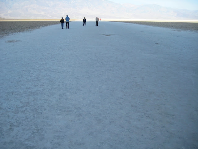
Walking on the salt flats beyond boardwalk at Badwater.

You can walk about 3/4 mile out on the salt flats.

Death Valley salt flats, left by evaporation of Lake Manley after the last Ice Age, 10,000-15,000 years ago.
.heic)
Death Valley south of Badwater.
We continued south and were out of Death Valley about 50 miles beyond Badwater. Soon we arrived at Shoshone Village. It's situated within the Shoshone Wetlands Preserve, which contains several birding trails.
We spent a few minutes in the small museum looking at pictures and stories of pioneer women of Amargosa Valley and old farm and mining equipment. Outside was a nice display of area rocks, with explanations of each geologic era they represent.
We decided to continue south about 7 miles to investigate China Ranch Date Farm. The pavement of China Ranch Road turned to dirt and began a steep curving descent that cut through an alluvial fan.

China Ranch Road cuts through an alluvial fan.
The sides of the alluvial fan rose high above us, looking like a lunar landscape. We passed a number of old mine shafts.

We imagined we'd see half a dozen date palms at the end of the road and not much more. Boy were we wrong!

What greeted us instead were groves of lush date palms! The small family date farm is the latest incarnation of an area that has produced various crops and livestock since the latter half of the 19th century. It was also a mining area, mainly for talc, lead, silver, and gypsum.

As we learned in A Modest Museum, it seems a certain Ah Foo farmed the area in the latter half of the 19th century, then disappeared around 1900. The land passed through various hands until its 1920s owner, having never seen a date, let alone a date palm, ordered date seeds and, when they arrived, planted them.

Those seeds grew into the towering date palms that continue today to line the drive to the handsome adobe house. One of the current owners is, serendipitously, Hawaiian of Chinese descent. They reinvigorated the date orchard in the 1990s and now grow nearly a dozen varieties of California and Middle Eastern origin.

Numerous varieties of date palm are grown at China Ranch.
The small store sells date products, local art, and collectibles. We sampled the dates, and I had to have a date shake—it was as delicious as the one I had forty years ago in Indio, CA.
China Ranch is an oasis. It was a watering spot on the Old Spanish Trail, which ran from Santa Fe to Los Angeles, and was a stopping place for the likes of John Fremont and Brigham Young. According to the sign on the side of the store, Kit Carson actually slept there.

The Amargosa River Trail begins behind the store, and we thought we'd walk down it a short way. We ended up spending over two hours exploring the area. The Amargosa (Spanish for "bitter") River begins in northeast Nevada, runs southwest underground, and emerges at Shoshone. From there it runs west some miles then dives underground again, ending back north in Badwater. In this area, it flows through the Amargosa Canyon and is under the control of the BLM.

Along Amargosa River Trail .
The trail is marked by cairns, some of which have become quite elaborate with the additions of passing hikers.

Trail duck.
After about a mile, we came to the confluence of Willow Creek and the Amargosa River.

Willow Creek & the Amargosa River flow through the area.

Greenery marks the banks of the river.
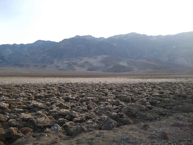
Despite the oasis at our back and the greenery along the creek, it's typical Mojave Desert here: sand on the flats and hills and mountains that vary in composition from black volcanic rock and cinder cones to upheaved layers of rock in various shades of brown.

Typical Mojave Desert landscape.
Leaving the stream behind, we followed the trail toward a sizable hill of mine tailings.

Doug walking toward large mound of mine tailings.
In mining days, this area was called Morrison.

Mine tailings. Note remains of wood structures.
The remains of the Tonopah and Tidewater Railroad bed run alongside the tailings at the foot of the mound. We surmised that the extracted minerals were pushed over the side of the mound through wooden chutes into waiting rail cars.

Ties of Tonopah & Tidewater Railroad bed running alongside mound of mine tailings.
We climbed the railroad embankment and walked along the ties.

Marilyn on the Tonapah & Tidewater RR bed
The BLM, with the support of the Rails-to-Trails Conservancy, is converting the railroad bed to a 17-mile trail.

As the trail turned back toward China Ranch, it was marked with typical brown metal stakes.

Looking from trail to China Date Ranch.
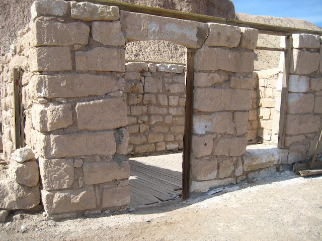
Brown, green, and blue bits of glass glinted in the sun on a slope where the trail curved down to the remains of the assay office.

Trail down to assay office.
 Assay office.
Wooden floor of assay office remains in place.
We thought the assay office might later have been a saloon. The remains of a nearby box spring seemed to support this conjecture, since saloons typically provided the services of ladies of the night.

Boxspring near assay office/saloon.
Nearby was a dump containing an assortment of old metal cans, boxes, car parts, box springs, and a few pieces of broken pottery.

Dump near former assay office/saloon.
Particularly eerie were the crib-size box springs, one with a mesquite bush pushing thick pointed branches up through it.

Crib box spring.
We left China Ranch more than content with our discovery and in a few minutes were in Tecopa.
Tecopa is typical of many desert communities that came into existence around mining or an oasis: mostly poor homes, often a trailer plunked down on the land, very limited services, a small elementary school, remains of former mines and evidence of current mines, scraggly desert vegetation, and flatlands, hills, and mountains with fascinating geology.

Tecopa Elementary School.
We decided to spend the night at Tecopa Hot Springs Campground.


We parked in a tent site under a tree at the far end of the campground, then headed to soak in the spring-fed hot tubs. The various minerals are touted for relieving fungus, building muscle mass, strengthening bones, increasing brain activity, converting blood sugar to energy, promoting healthy skin, normalizing heart rhythm, reducing high blood pressure, alleviating arthritis, and more. And to think, for all that, all we had to do was sit!

Campsite, Tecopa Hot Springs Campground
The desert sky that night was black, with the moon, Jupiter, and Venus standing out among the mass of stars. We were snug in our sleeping bag when the winds came up again during the night, with the tree providing a buffer.

Across the valley from the campground.
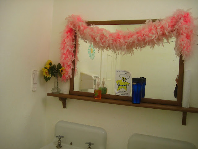
In the morning we continued north a half hour to Death Valley Junction and the Amargosa Hotel and Opera House.

Amargosa Hotel & Opera House.
Built in 1923 as the civic center of the Pacific Coast Borax Company, the buildings included company offices, a store, an employee dorm, a hotel, a dining room, a gym, a billiard room, an ice cream parlor, and a community center. Remember the 20 Mule Team Borax commercials?
Marta Becket stumbled on Death Valley Junction in 1967, converted the community center to the Opera House, and performed there for 40 years.

Marta also painted murals throughout the hotel.

Though it was closed the day of our 2012 visit, as of 2024, the Opera House is open for tours, and the hotel is open to guests.
Before we reached I-95 to drive north through Nevada to Beatty, we came across a sign to Ash Meadows National Wildlife Refuge. Of course we turned off and drove the short distance to the Visitor Center. There an enthusiastic and informative ranger greeted us.


As we stood on a boardwalk overlooking Crystal Spring, he informed us that the refuge has 50 springs—in the middle of the Mojave Desert! Fed by an underground aquifer, the springs have a total output of 10,000 gallons per minute. That's a lot of water, desert or no desert!

We spent the next 3 hours at the refuge. Going between springs was easy, thanks to well-maintained dirt roads.

Among the numerous species of plants and animals that thrive in the desert oasis, more than 20 are found nowhere else in the world.
 The blue water and gurgling sounds of the springs were mesmerizing.
We spotted desert pupfish in two of the springs. Some of the males are bright blue, the shade they turn during breeding season. Most pupfish live less than a year.

At Longstreet Cabin, the restored home of a 19th-century miner and his Native American wife, we flushed a huge jack rabbit that bounded away from us. At another spring we heard a healthy bullfrog.

Our last stop was to investigate a windmill-like contraption on a hill. We parked the VW on the side of the dirt road and made our way up through low-growing bushes, giving them a wide birth so as not to disturb any lingering rattlesnakes.

We decided the contraption was a drill for wells, a Rube Goldberg set-up that included an old car engine for power.
 VW parked down the hill.
Heading back down the hill, we spotted another heap of old metal objects and wood from a building in the process of being removed. Poking through abandoned junk piles feels a bit like poking through history. We like to see what's there, in this case a few pieces from old dishes.
We will return to Ash Meadow, as there is a good deal we did not explore, but it was time to move on.
Soon we drove through Beatty NV and turned back west on Death Valley Road to Rhyolite Ghost Town.

Gold mining brought Rhyolite into existence in 1904. It quickly became a bona fide town, complete with a school.


Typical of mining towns, it died just as quickly, becoming a ghost town in a decade.

Deserts being short on wood, Tom Kelly, who arrived in Rhyolite seeking gold, built his house out of 50,000 bottles collected from the 50 saloons in town.


Marta also painted murals throughout the hotel.

Opera House doors.
Though it was closed the day of our 2012 visit, as of 2024, the Opera House is open for tours, and the hotel is open to guests.

Boa hung on ladies' room mirror at hotel reminiscent of Marta Becket's flourishes.
Before we reached I-95 to drive north through Nevada to Beatty, we came across a sign to Ash Meadows National Wildlife Refuge. Of course we turned off and drove the short distance to the Visitor Center. There an enthusiastic and informative ranger greeted us.


As we stood on a boardwalk overlooking Crystal Spring, he informed us that the refuge has 50 springs—in the middle of the Mojave Desert! Fed by an underground aquifer, the springs have a total output of 10,000 gallons per minute. That's a lot of water, desert or no desert!

Stream flowing from Crystal Spring, 1 of 50 in Ash Meadows.
We spent the next 3 hours at the refuge. Going between springs was easy, thanks to well-maintained dirt roads.

An abundance of water in the Mojave Desert.
 The blue water and gurgling sounds of the springs were mesmerizing.
We spotted desert pupfish in two of the springs. Some of the males are bright blue, the shade they turn during breeding season. Most pupfish live less than a year.

At Longstreet Cabin, the restored home of a 19th-century miner and his Native American wife, we flushed a huge jack rabbit that bounded away from us. At another spring we heard a healthy bullfrog.

Doug at Rogers Spring.
Our last stop was to investigate a windmill-like contraption on a hill. We parked the VW on the side of the dirt road and made our way up through low-growing bushes, giving them a wide birth so as not to disturb any lingering rattlesnakes.

Doug & the mystery contraption.
We decided the contraption was a drill for wells, a Rube Goldberg set-up that included an old car engine for power.
 VW parked down the hill.
Heading back down the hill, we spotted another heap of old metal objects and wood from a building in the process of being removed. Poking through abandoned junk piles feels a bit like poking through history. We like to see what's there, in this case a few pieces from old dishes.
We will return to Ash Meadow, as there is a good deal we did not explore, but it was time to move on.
Soon we drove through Beatty NV and turned back west on Death Valley Road to Rhyolite Ghost Town.

VW at Rhyolite train station.
Gold mining brought Rhyolite into existence in 1904. It quickly became a bona fide town, complete with a school.

Cook Bank.

Grocery Store.
Typical of mining towns, it died just as quickly, becoming a ghost town in a decade.

Train depot.

VW parked next to bottle house.
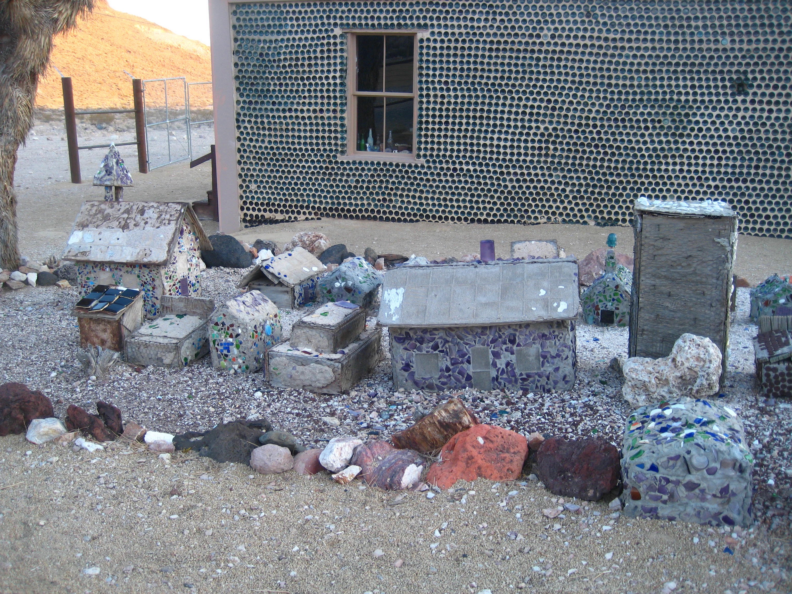
Later occupants built an entire miniature town in the yard.
Standing among the remains of Rhyolite, one can almost hear the hustle and bustle of the 8,000 people who once lived here.
Down the hill from town, rows of mostly unmarked mounds populate the cemetery. One stands out, fenced in and fancifully ornamented: the gravesite of one Isabel Haskins, aka Mona Belle, former inhabitant of the red light district. According to legend, the grave did not exist until 20 years after Mona Belle's tragic death.

Mona Belle's grave site.
We spent our last night at Emigrant, a 10-site free campground a few miles west of Stovepipe Wells. We slid into sleep looking through the Vanagon's back window at the moon and planets, the Big Dipper, Cassiopeia, Orion the Hunter, the Pleiades, and the countless other stars and constellations in the vast darkness and quiet of our last desert night.
When we reached 395 the final morning of our trip, we decided to head north to visit Manzanar, 1 of 10 "relocation" centers to which tens of thousands of Japanese Americans, the majority of them American citizens, were moved within months of the bombing of Pearl Harbor. It was designated Manzanar National Historic Site in 1992.
.heic)
East side of Sierras.
The former high school gymnasium serves as headquarters and information center. Over 11,000 people were interned here for all or part of the center's existence, which ended a few months after Japan's surrender in 1945.

East side of the Sierras en route to Manzanar
We visited the information center then walked through replicas of barracks and a mess hall. Recorded sounds gave the sense of ghosts of those who endured the camp. Eight-by-ten-foot gray mesh screens with photographs of people cooking and eating hung among the long tables and benches, creating an atmosphere of confinement and lack of privacy. Every aspect of life here was communal. People made their crowded barracks quarters as comfortable as possible and turned the desert colorful with crops and gardens. Reconstruction of the camp's buildings has been ongoing. We came across concrete-lined ponds and bridges, the remains of garden parks the residents created. A design in pebbles gives the date one garden was constructed.
The cemetery remains outside the grounds. A snow-white obelisk, with the snow-capped Sierras beyond, is lettered in Japanese characters in black meaning "soul consoling tower." The cemetery and displays at Manzanar rightfully demand that we remember this event and contemplate its meaning for our nation.
We made one more stop, in Lone Pine. There we looked up at the east side of the Sierras and Mt Whitney before continuing our drive to home on the Sierras' west side. We'd been to the lowest point in the continental US at Badwater and now looked at its highest point, Mt Whitney, and in between those bookends we'd experienced the fascination and contemplation of geology and history.
Comments
Post a Comment
We love hearing from our readers! If you wish your comment not to be "Anonymous," you can sign into your Google account or simply leave your name at the end of your comment. Thanks!